Village reported in 1962 by U.S. Geological Survey (USGS); named "for Arthur Anderson, who subdivided his homestead into quarter-acre lots and was elected one of the first councilmen" (Alaska Sportsman, Sept. 1962, p. 12). Description: 5 mi. NW of Clear, 12 mi. SW of Nenana, Tanana Low
"Located just six miles from the ballistic missile early warning radar system at clear Air Force Station, this small community of fewer than 500 persons is nestled in the Alaskan wilderness. There are one store, two churches, a school and an airstrip. The trading area for Anderson citizens is Fairbanks, and 87 mile drive or flight. In winter, temperatures dip to 40 and 50 degrees below zero." --Oregonian, 19 Apr 1980
"In the 1960s, a road was completed between Anderson and Nenana. A ferry across the Tanana River at Nenana provided access to the Fairbanks–Nenana Highway, and hence to Fairbanks and the contiguous North American highway system via the Richardson and Alaska Highways. The ferry was replaced with a bridge in 1968. In 1972, the George Parks Highway was completed, which provided direct road access to points south, including Anchorage." --Wikipedia
This was a mining camp, established in 1905 and called "Bear Paw City" by prospectors; reported in 1905 by L. M. Prindle, U.S. Geological Survey (USGS). Description: on right bank of Bearpaw River, 48 mi. SE of Bitzshtini Mts., Tanana Low.
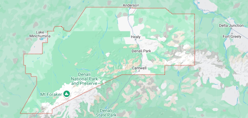
"Cantwell is located in the southern part of Denali Borough at 63°23′17″N 148°54′1″W (63.388000, -148.900204). It is situated at the north end of Broad Pass, along Cantwell Creek and the Jack River, tributaries of the north-flowing Nenana River. Alaska Route 3, the George Parks Highway, passes through Cantwell: Anchorage is 212 miles to the south, and Fairbanks is 150 miles to the north." --Wikipedia
"The only inhabitants of the Cantwell area were nomadic Tanana Indians and
Athabascan Native Alaskans who hunted and fished. In their language they named
Cantwell Yede'teni'na. The town began as a flag stop on the Alaska Railroad.
This flagstop supplied the Valdez Creek mining area, which had the name "Denali"
for the Valdez Creek community. Many Indians from the village of Tyone came to
work at Valdez Creek and later lived out their lives in the Cantwell area. Many
Tyones are buried in the old Cantwell graveyard, next to the railroad tracks.
"Oley Nicklie, a Native Alaskan, sought work with the railroad after fur
prices dropped. He and his two brothers then founded part of the Cantwell
settlement." --Wikipedia
Cantwell began as a flag stop on The Alaska RR. as reported on its 1922 timetable. It was named for the "Cantwell River," the former name of the Nenana River. The Cantwell River was named after Lieutenant J. C. Cantwell, military explorer and commander of the revenue steamer Corwin on the Yukon River, 1898-1900.
At Mile 203.6 of the George Parks Highway is Broad Pass, a dividing line where rivers to the south drain into Cook Inlet, while
those to the north flow to the Yukon River. The pass is one of the most beautiful spots along the Parks Highway and the Alaska Railroad as
both uses the low gap to cross the Alaska Range. At an elevation of 2,300 feet, the area is a stunning mountain valley at tree line and
surrounded by tall white peaks. Sitting to the north end of Broad Pass where the Nenana River curves north and cuts through the Alaska
Range is Cantwell, population 192.
Thanks to the many people who visit Denali National Park and Preserve, 28 miles north, Cantwell is a
full-service community that provides lodging, camping, food and fuel right along the George Parks Highway, which connects Anchorage and
Fairbanks.
Named after the Cantwell River, the original name for the Nenana River, Cantwell was established in the mid-1920s as a railroad construction camp and later became a flag stop for trains traveling between Anchorage and Fairbanks. After the Parks Highway was constructed in 1971, the town’s commercial district shifted to the intersection of the Parks and Denali Highways as Cantwell's economy became more dependent on highway tourism and transportation.
Denali National Park and Preserve, 237 miles from Anchorage and about half that distance from Fairbanks, is an immense subarctic wilderness centered on Mount McKinley – North America’s highest peak at 20,320 feet. From the gateway of the national park stretching along the George Parks Highway is Denali Park, a collection of mostly seasonal businesses providing visitor services. The nearest year-round community to the park is Healy, population 1,025, at Mile 248.7.
"Clear is an unincorporated community in Denali Borough, Alaska. The small community is along the George Parks Highway at milepost 280 and encompasses residential homes and businesses. Its elevation is 518 feet (158 m). Clear is 4 miles south of the Alaska Railroad Clear Site station established about 1918 at mile 392.9 ARR. It is 5 miles south of Clear Air Force Station." --Wikipedia
This camp was established about 1905 at the head of small-boat navigation on the Bearpaw River. It had a post office in 1906 and again from 1929 to 1951 (Ricks, 1965, p. 16). Description: site of mining camp, at junction of Moose Creek and Bearpaw River, 18 mi. E of Chilchukabena Lake, Tanan Low.
Ferry was published as railroad station on a timetable in 1922. Earlier, the place was listed as Nenana River on a Seattle Chamber of Commerce promotion folder. Located in northern Denali Borough at mile 371.2 on The Alaska RR., at Nenana River, 39 mi. S of Nenana.
"Ferry first appeared on the 1940 U.S. Census as an unincorporated village [population 31]. It did not appear again until 1990, when it was made a census-designated place [population 56]." --Wikipedia
History: Name of a flag stop reported by the Alaska RR. on its 1922 timetable. Description: mile 355.7 on The Alaska Rr., W of Nenana River, 2 mi. S of Healy, Alaska Range.
Village established as a mining camp about 1905; named after the Healy Creek. Because of its nearness to the Alaska RR right-of-way, it became a RR station and supply point. The "Healy Fork" post office was established in 1921 (Ricks, 1965, p. 25). Its population was 36 in 1930. It is a major coal mining supply center. Located on the Nenana River, northwest of the mouth of Healy Creek, at Mile 248.7, and 78 miles SSW of Fairbanks.
Healy has many businesses that serve highway travelers and park visitors including a gas station, hotels, bed and breakfasts, restaurants, gift shops, auto repair shop, grocery store and RV parks. Many are open year-round.
To the north of Healy, on the highway's western side, is the historic Stampede Trail, originally built in the 1930s as a route to the Stampede Mine, once Alaska's prime producer of antimony. The mine ceased operations in 1970, and since 1980 its abandoned mill and other buildings have been located within Denali National Park and Preserve’s expanded borders. Much of the trail is now within Denali, but its first 25 to 30 miles are outside of the park. Today the trail is a rugged track used primarily by snowmobilers, mushers and skiers in late winter, when travel is easier. The wilderness trail does draw a number of summer visitors who want to view the Fairbanks City bus where Chris McCandless, the subject of Jon Krakauer’s 1997 bestseller Into The Wild, lived and died.
Located in Kantishna Hills, at junction of Eureka and Moose Creeks, 3 miles
northwest of Wonder Lake, near the mouth of the Kantishna River. In the early
days, it was called "Eureka," named for the stream. A post office named
"Kantishna" was established in 1905 near the mouth of the Kantishna River. The
Kantishna gold mining camp was one of several camps that appeared suddenly when
gold was discovered in the Kantishna Hills. Most of the camps were abandoned a
short time later, but this one was nearest the producing creeks.
Touristy Description: For many, Kantishna provides the ultimate lodging location in Denali National Park and Preserve. Although not part of
the national park, visitors here are surrounded by parkland and feel as close to nature as anywhere in Alaska. The wilderness resorts at
the end of the road are luxurious and most include meals and round-trip transportation from the park entrance. The bonus of staying in
Kantishna is a clear day when Mount McKinley looms just overhead.
The settlement of Kantishna was founded in 1905 as a mining camp near the juncture of Eureka and Moose Creeks. Gold in the region brought a flurry of prospectors in the early days, but as the gold began to run out so did interest in mining the Kantishna Hills. Kantishna and much of the surrounding area is now private property supporting a summer population of 135 and nobody in the winter.
History: Name of a railroad station reported by The Alaska RR. on its 1922 timetable. Description: mile 343.7 on The Alaska RR., 12 mi. S of Healy, Alaska Range.
History: Name of a railroad station reported by The Alaskan RR. on its 1922 timetable; derived from the lignite coal found in the area. This station was originally named "Dry Creek." Description: mile 363.3 on the Alaska RR., 4 mi. N of Healy, Alaska Range.
The settlement reported in 1920 as Riley Creek, perhaps in a slightly different location than the present place. The Riley post office was established in 1922 and its name changed to Mckinley Park the same year (Ricks, 1965, p. 40). Its population was listed as 49 in the 1930 census. Located at Mile 347.9 on The Alaska RR, 9 miles south of Healy.
History: This place began as a railroad camp; first called "Summit Lake" on a 1919 manuscript location map of the railroad. Description: population 39, mi. 312.5 on The Alaska RR., SW of Mirror Lake, 37 mi. S of Healy, Alaska Range.
The village and mining camp listed with a population of 61 in the 1930 Census, 78 in 1939, and 130 in 1950. The town and mine at Suntrana no longer exist, the site of company housing is now reforested, no remains of the mine, power house, or old tipple complex remains.
Located in eastern Denali Borough, on right bank of Healy River at mouth of Suntrana Creek, 3.5 mi. E of Healy, Alaska Range. "Suntrana lies along the George Parks Highway south of the city of Anderson, the county seat of Denali Borough, and on the northeastern edge of Denali National Park and Preserve." --Wikipedia
Usibell is located 5 miles east of Healy, and connected to the Parks Highway
by Healy Spur Road.
"It was named for the Usibelli Coal Mine, the mine
is the chief economic enterprise in the area. With its large deposits and its
status as the only coal mine in the state, Usibelli Coal Mine has long been
prominent; it is a primary supplier for coal-fired power plants in the Fairbanks
area and in southern Alaska, and it exports coal to South Korea and Chile. In
recent years, the mine has stood to benefit from efforts for American energy
independence; a bill in the United States Senate in 2008 was amended to
encourage conversion of coal into liquid fuels for the use of the United States
Air Force." --Wikipedia