

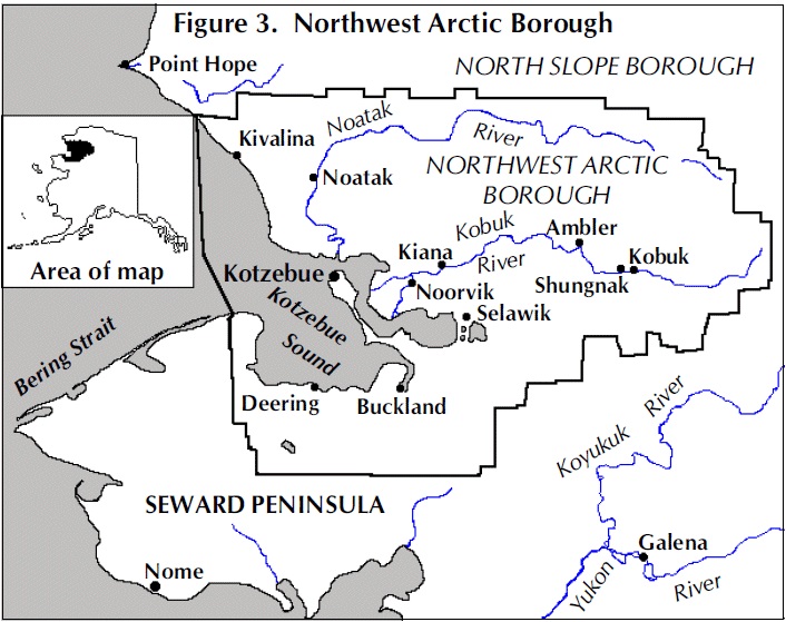
Northwest Arctic Borough
AKGenWeb

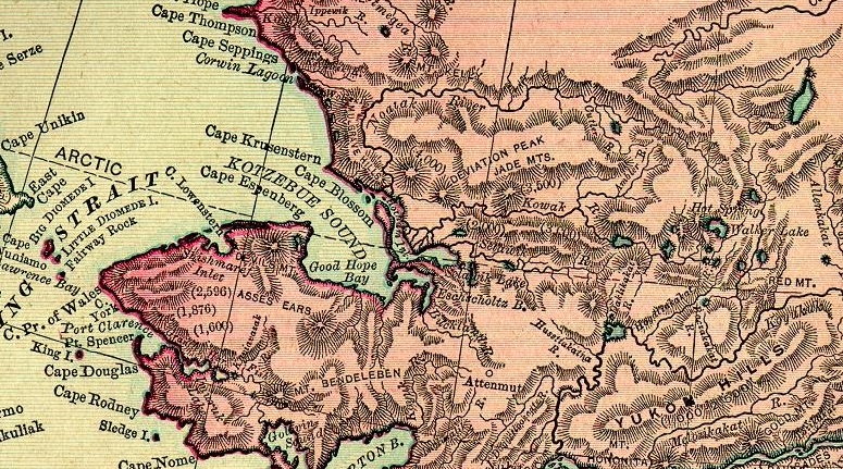
1895 Rand McNally Atlas
Courtesy of Pam Reitsch
Source: Unknown
Population: 259
Ambler is a city in Northwest Arctic Borough, Alaska, United States. At the 2000 census the population was 309. The city is located in the
large Inupiaq language speaking region of Alaska, and the local dialect is known as the Ambler dialect (related to the Shugnak dialect). As
of 1999, over 91% of the community speaks and understands the language (Kraus, 1999), with many young children actively learning the
language in school.
Ambler is located on the north bank of the Kobuk River, near the confluence of the Ambler and the Kobuk Rivers.
It lies 45 miles north of the Arctic Circle. It is 138 miles northeast of Kotzebue, 30 miles northwest of northwest of Kobuk and 30 miles
downriver from Shungnak. Ambler is located in the Kotzebue Recording District.
The community was named for a tributary of the Kobuk
River, which was named for Dr.James M. Ambler, who died of starvation after his ship was trapped in the Arctic ice in 1881. Ambler was
permanently settled in 1958 when people from Shungnak and Kobuk moved upstream because of the variety of fish, wild game and spruce trees
in the area. An archaeological site is located nearby at Onion Portage. A post office was established in 1963. The City was incorporated in
1971.
Ambler's major means of transportation are by barge, plane, small boat and snowmachine. There are no roads linking the City
to other parts of the state. Cash employment is limited to the school, City, clinic, and local stores, and some mining occurs. Five
residents hold commercial fishing permits. Subsistence is a major part of the local economy. Chum salmon and caribou are the most important
food sources. Freshwater fish, moose, bear, and berries are also harvested. Birch baskets, fur pelts, and jade, quartz, bone and ivory
carvings are sold in gift shops throughout the state. The community is interested in developing a lapidary facility for local artisans
Population: not listed
No information except that it is located on USGS Ambler River A-2 map.
Population: 458
Eskimo village and trading post reported by U.S. Geological Survey (USGS) in 1914. Its population was 52 in 1920; 104 in 1930; and 115 in 1940. The Buckland post office was established here in 1935 and discontinued about 1941. The present Buckland post office is located at Elephant Point. Located on Buckland River, 54 mi. N of Haycock.
Buckland is located on the west bank of the Buckland River, about 75 miles southeast of Kotzebue. Buckland is located in the Cape Nome Recording District. Temperatures range from -60 to the 85 °F. Annual precipitation averages 9 inches, and annual snowfall averages 40 inches. Crosswinds can restrict flying during the winter.
History: The residents have moved from one site to another along the river at least five times in recent memory, to
places known as Elephant Point, Old Buckland, and New Site. The presence of many fossil finds at Elephant Point indicate prehistoric
occupation of the area. The Inupiaq people depend on reindeer, beluga whale, and seal for survival. The city government was incorporated in
1966.
Buckland is an Inupiat village, and subsistence activities are an important focus of the economy. The sale or importation of
alcohol is banned in the village.
Economy: Residents depend on a subsistence lifestyle for most food sources. Employment is primarily with the school, city, health clinic, and stores. Some mining also occurs.
Facilities: Water is pumped from Buckland River, treated in the washeteria building, and stored in a 100,000-gallon tank. Some residents have water delivered to home tanks, but most haul their own water. The city pumps flush/haul waste tanks or hauls honeybuckets to the sewage lagoon. A flush/haul system has been problematic on the south side of town, and it sometimes freezes and fails during the winter. Only 8 homes and the school have functioning plumbing; 74 homes are not served. Individuals dispose of refuse in dumpsters, which are hauled to the landfill.
Transportation: Buckland's major means of transportation are plane, small boat, barge, and snowmachine; there are no roads outside of the village. Crowley Marine barges in fuel, and various lighterage companies deliver cargo and supplies each summer.
Population: 103
Mining camp established about 1901-2 and named for Candle Creek; published by U.S. Geological Survey (USGS). Its population was 204 in 1910; 91 in 1920; 85 in 1930; 119 in 1939; and 105 in 1950. The Candle post office was established in 1902.
Located on left bank of Kiwalik River, 54 mi. NW of Haycock, Seward Peninsula High. Chicago Creek Site of a mining camp; named on a 1951 U.S. Geological Survey (USGS) map. A coal mine was opened here in 1903 and for many years supplied coal to the Candle Creek and Fairhaven gold mining districts. Located on right bank of Kugruk River, 29 mi. NE of Imuruk
Population: 133
The village was established in 1901 as a supply station for interior gold mining near the historic Malemiut Eskimo village of Inmachukmiut. The name probably comes from the schooner Abbie M. Deering, which was present in the area at that time. A post office was located here in 1901. The inhabitants are primarily Iñupiat Eskimo. It is located on a sandy spit on the Seward Peninsula where the Inmachuk River flows into Kotzebue Sound, 57 mi southwest of Kotzebue.
Location: Deering is located on Kotzebue Sound at the mouth of the Inmachuk River, 57 miles southwest of Kotzebue. It is built on a flat sand and gravel spit 300 feet wide and a half-mile long. Deering is located in the Cape Nome Recording District and is in the transitional climate zone, which is characterized by long, cold winters and cool summers. The average low temperature during January is -18 degrees Fahrenheit. The average high during July is 63 degrees Fahrenheit. Temperature extremes from a low of -60 to a high of 85 degrees Fahrenheit have been measured. Snowfall averages 36 inches, and total precipitation averages 9 inches per year. Kotzebue Sound is ice-free from early July until mid-October.
History: The village was established in 1901 as a supply station for Interior gold mining near the historic Malemiut Eskimo village of "Inmachukmiut." The name Deering was probably taken from the 90-ton schooner "Abbey Deering," which was in nearby waters around 1900. The City was incorporated in 1970.
Culture: The population of the village is primarily Inupiat . The people are active in subsistence. The sale or importation of alcohol is banned in the village.
Economy: Deering's economy is a mix of cash and subsistence activities. Moose, seal and beluga whale provide most meat sources; pink salmon, tom cod, herring, ptarmigan, rabbit and waterfowl are also utilized. The Karmun-Moto reindeer herd of 1,400 animals provides some local employment. A number of residents earn income from handicrafts and trapping. The village is interested in developing a craft production facility and cultural center to train youth in Native crafts. The school, City, Maniilaq Assoc., stores, and an airline provide the only year-round jobs. Some mining occurs in the Seward Peninsula's interior. Two residents hold commercial fishing permits. The village wants to develop eco-tourism, including a 38-mile road to Inmachuk Springs for tourists.
Population: 87
Located on a spit on S coast of Eschscholtz Bay, 44 mi. SW of SelawikEspenberg Name of a settlement reported in 1950 by U.S. Geological Survey (USGS). Recent U.S. Geological Survey (USGS) maps indicate a site with five or six buildings. Name derived from nearby Cape Espenberg. Located on Seward Peninsula, at mouth of Espenberg River, on Chukchi Sea, 50 mi. NW of Deering.Fink Creek Reported in 1923 on an Alaska Road Commission (ARC) map. Located on left bank Inmachuk River, 1 mi. SW of Utica and 20 mi. NNE of Imuruk Lake, Seward Peninsula High.
Population: Historical
Former Eskimo village visited in 1885 by Lieutenant G. M. Stoney, U.S. Navy (USN). He wrote the name "Kallamute," i.e. "Kalla people." Located on right bank of Kobuk River, 14 mi. E of Shungnak.
Population: 383
Eskimo village, which probably obtained its permanency as a supply center for the Squirrel River placer mines about 1909. Reported by H.M. Eakin, U.S. Geological Survey (USGS), in 1910; was established in 1915. Population 181 in 1950. Located on the right bank of Kobuk River, 28 mi. NW of Selawik.
Location: Kiana is located on the north bank of the Kobuk River, 57 air miles east of Kotzebue and is in the Kotzebue Recording District. The area encompasses 0.2 sq. miles of land and 0.0 sq. miles of water. Kiana is located in the transitional climate zone. Temperatures average -10 to 15 during winter; 40 to 60 during summer. Temperature extremes have been recorded from -54 to 87. Snowfall averages 60 inches, with 16 inches of total precipitation per year. The Kobuk River is navigable from the end of May to early October.
History: Kiana means "a place where three rivers meet." It was established long ago as the central village of the Kobuk River Kowagmiut Inupiat. In 1909, it became a supply center for the Squirrel River placer mines. A post office was established in 1915. The City government was incorporated in 1964. Prior to the formation of the Northwest Arctic Borough in 1976, the BIA high school taught students from Noatak, Shungnak and Ambler, who boarded with local residents. Culture: Kiana is a traditional Inupiat village practicing a subsistence lifestyle. The sale or importation of alcohol is banned in the village.
Economy: The economy depends on traditional subsistence activities, augmented by a cash economy. Chum salmon, freshwater fish, moose, caribou, waterfowl and berries are harvested. The school, City, and Maniilaq Association provide the majority of year-round jobs. The Red Dog Mine also offers area employment. Kiana is one of the more modern villages in the Borough, and has three general stores. Three residents hold commercial fishing permits; seasonal employment also includes work on river barges, BLM fire-fighting and jade mining. There is local interest in constructing a whitefish and turbot value-added processing plant. The City is also interested in developing eco-tourism, primarily guided river trips to the Great Kobuk Sand Dunes.
Population: 406
Eskimo village originally located at the north end of the lagoon. Reported in 1847 by Lieutenant L.A. Zagoskin, Imperial Russian Navy
(IRN), who gave its name as "Kivualinagmut". The village population was 87 in 1920, 99 in 1930, 98 in 1939, and 117 in 1950. The post
office was established in 1940. Located on barrier reef between Chukchi and Kivalina Lagoon, 43 mi NW of Noatak and 47 mi NW of Cape
Krusenstern.
It has long been a stopping place for travelers between Arctic coastal areas and Kotzebue Sound communities. Three bodies
and artifacts were found in 2009 representing the Ipiutak culture, a pre-Thule, non-whaling civilization that disappeared over a millenium
ago. It is the only village in the region where people hunt the bowhead whale. The original village was located at the north end of the
Kivalina Lagoon but was relocated. In about 1900, reindeer were brought to the area and some people were trained as reindeer herders.
Location: Kivalina is at the tip of an 8-mile barrier reef located between the Chukchi Sea and Kivalina River. It lies 80 air miles northwest of Kotzebue. Kivalina is located in the Kotzebue Recording District. The average low temperature during January is -15 °F; the average high during July is 57 °F. Temperature extremes have been measured from -54 to 85 °F. Snowfall averages 57 inches, with 8.6 inches of precipitation per year. The Chukchi Sea is ice-free and open to boat traffic from mid-June to the first of November.
History: Kivalina has long been a stopping-off place for seasonal travelers between Arctic coastal areas and Kotzebue Sound communities. It is the only village in the Northwest Arctic Borough region where people hunt the bowhead whale. At one time, the village was located at the north end of the Kivalina Lagoon. It was reported as "Kivualinagmut" in 1847 by Lt. Zagoskin of the Russian Navy. Lt. G.M. Stoney of the U.S. Navy reported the village as "Kuveleek" in 1885. A post office was established in 1940. An airstrip was built in 1960, using metal mattings. Kivalina incorporated as a city in 1969. During the 1970s, new houses, a new school, and an electric system were constructed in the village. Prior to 1976, high school students from Noatak would attend school in Kivalina and board with local families. Due to severe erosion and wind-driven ice damage, the city intends to relocate to a new site 2.5 miles away. Relocation alternatives have been studied, and a new site has been designed and engineered.
Culture: Kivalina is a traditional Inupiat village. Subsistence activities, including whaling, provide most food sources. Inupiaq dancing was reintroduced by a group of young people in September of 2008. The sale or importation of alcohol is banned in the village.
Economy: Kivalina's economy depends on subsistence practices. Bearded seal, walrus, bowhead whale, Dolly Varden trout, tomcods, blue cods, salmon, whitefish, and caribou are utilized. The school, city, Maniilaq Association, NANA Regional Corporation, tribal council, airlines, and local stores provide year-round jobs. The Red Dog Mine also offers some employment. Two residents hold commercial fishing permits. Native carvings and jewelry are produced from ivory and whalebones. The community is interested in developing an Arts and Crafts Center that could be readily moved to the new city site.
Facilities: Water is drawn from the Wulik River via a 3-mile surface transmission line to a 700,000-gallon raw water tank and then to a 500,000-gallon tank, where it is treated when it is pumped. The water lasts the community only for a six-month period, and the washeteria is closed to the public when the last tank is down to 12 feet, and only the school uses the water, so it can last through May. Water is limited to 30 gallons a day for the public during this period.
Water is hauled by residents from this tank, which can be difficult during winter, given that there are snowhills 20 to 30 feet high in the community. One-seventh of residents have tanks which provide running water for the kitchen, but homes are not fully plumbed. There is only a public washeteria with three showers available. The school and clinic have individual water and sewer systems. Residents haul their own honeybuckets to the landfill disposal wite, which has no barrier around it and is subject to visits from wild animals, such as bears and foxes. The seagulls and crows that forage for food at the landfill are a threat to incoming airplanes.
Population: 10
Eskimo village named for the Kiwalik River, reported in 1850 as "Kualiug-miut" by Lieutenant L. A. Zagoskin, Imperial Russian Navy (IRN), and published in 1852 on Russian Hydrographic Dept. Chart 1455. Census as "Kugalukmute," population 12. became a supply point for mining activities in the Candle area.
The Keewalik post office was established in 1902 and operated intermittently until 1907. increased to 24 in 1940. Located on NE coast of Seward Peninsula, between Spafarief Bay and Kiwalik Lagoon.Klery Creek Name reported on a 1923 Alaska Road Commission (ARC) map. Located on Klery Creek, at mouth of Jack Creek W of Kallarichuk Hills and 20 mi. NE of Deviation Peak, Brooks Range
Population: 109
Village established about 1899 as a supply point for the mining activities in the Cosmos Hills to the north. It was then called Shungnak. Because the village was the location of a trading post, school, and Friends mission, it became primarily an Eskimo settlement by 1910. Due to river erosion the population of Shungnak decided to relocate at a new site called "Kochuk" about 10 miles downstream in the 1920's. The few families that remained behind, and some who returned, renamed the village "Kobuk." The Shungnak post office was established in 1903; the name was changed to Kobuk in 1928. In May 1973, a flood covered the entire village.The economy of Kobuk is based on subsistence hunting for caribou and moose. Located on right bank of Kobuk River 7 mi. NE of Shungnak.
Location: Kobuk is located on the right bank of the Kobuk River, about 7 miles northeast of Shungnak and 128 air miles northeast of Kotzebue. It is the smallest village in the Northwest Arctic Borough. Kobuk is located in the Kotzebue Recording District. Kobuk is located in the transitional climate zone. Temperatures average -10 to 15 during winter; 40 to 65 during summer. Temperature extremes have been recorded from -68 to 90. Snowfall averages 56 inches, with 17 inches of total precipitation per year. The Kobuk River is navigable from the end of May through October.
History: Kobuk was founded in 1899 as a supply point for mining activities in the Cosmos Hills to the north, and was then called Shungnak. A trading post, school, and Friends Mission drew area residents to the settlement. Due to river erosion and flooding, the village was relocated in the 1920s to a new site 10 miles downstream, which was called "Kochuk," now Shungnak. The few who remained at the village renamed it Kobuk. Ice jams on the River cause high water each year. In May 1973, a flood covered the entire village. In October 1973, the City was incorporated.
Culture: It is an Inupiat village practicing a traditional subsistence lifestyle. The sale or importation of alcohol
is banned in the village. High School students attend school in Shungnak.
Economy: The economy of Kobuk is based on subsistence.
Whitefish, caribou and moose provide the majority of meat sources. Cash employment is limited to the school, City and Maniilaq clinic.
Seasonal construction and BLM fire fighting provide some income.
Facilities: A piped water and sewer system, provides services to the community. A 30-foot well provides water, which is treated and stored by the washeteria. The washeteria has its own septic tank. Waste is disposed of at Dall Creek. A landfill is also available. Kobuk Valley Electric Co-op purchases power from AVEC over the Kobuk-Shungnak intertie.
Population: 3126
Kotzebue is the Borough Seat and largest city in the Northwest Arctic Borough. It gets its name from the Kotzebue Sound, which was named after Otto von Kotzebue, who explored the sound while searching for the Northwest Passage in the service of Russia in 1818. Established as a permanent Eskimo village when a reindeer station was located here about 1897. Prior to then, it was a summer fish camp, first mentioned by Lieutenant Zagoskin (1847, pt. 1, p. 74), Imperial Russian Navy (IRN), who recorded the name as "Kikikhtagyut." The 1880 Census lists the name as "Kikiktagamute," A post office was established in 1899. A Society of Friends mission was founded the same year.
There is archaeological evidence that Inupiat people have lived at Kotzebue since at least the 1400s. Because of its location, Kotzebue was a trading and gathering center for the entire area. The Noatak, Selawik and Kobuk Rivers drain into the Kotzebue Sound near Kotzebue to form a center for transportation to points inland. In addition to people from interior villages, inhabitants of the Russian Far East came to trade at Kotzebue. Furs, seal-oil, hides, rifles, ammunition, and seal skins were some of the items traded. People also gathered for competitions like the current World Eskimo Indian Olympics [3]. With the arrival of the whalers, traders, gold seekers, and missionaries the trading center expanded. Kotzebue, was known by natives as Kikiktagruk or Qikiqtagruk, which means "almost an island" in Inupiaq, the language of the Inupiat, which is a reference to the spit. Reindeer herding was introduced in the area in 1897. Although Alaska had caribou, the wild form of reindeer, the domesticated reindeer were brought to Alaska from Asia. John Baker and Ed Iten, both top 10 finishers in the Iditarod Trail Sled Dog Race, are residents of Kotzebue. Located on NW shore of Baldwin Peninsula.
Location: Kotzebue is on the Baldwin Peninsula in Kotzebue Sound, on a 3-mile-long spit, which ranges in width from 1,100 to 3,600 feet. It is located near the discharges of the Kobuk, Noatak, and Selawik Rivers, 549 air miles northwest of Anchorage and 26 miles above the Arctic Circle. Kotzebue Recording District and is located in the transitional climate zone, which is characterized by long, cold winters and cool summers. The average low temperature during January is -12 °F. Snowfall averages 40 inches, with total precipitation of 9 inches per year. Kotzebue Sound is ice-free from early July until early October.
History: This site has been occupied by Inupiat for at least 600 years. "Kikiktagruk" was the hub of ancient Arctic trading routes long before European contact, due to its coastal location near a number of rivers. The German Lt. Otto Von Kotzebue "discovered" Kotzebue Sound in 1818 for Russia. The community was named after the Kotzebue Sound in 1899 when a post office was established. Since the turn of the century, expansion of economic activities and services in the area have enabled Kotzebue to develop relatively rapidly. The city was formed in 1958. An air force base and White Alice Communications System were later constructed.
Culture: The residents of Kotzebue are primarily Inupiat, and subsistence activities are an integral part of the lifestyle. Each summer, the North Tent City fish camp is set up to dry and smoke the season's catch. In 2009, Kotzebue became a "wet" community, allowing the sale, import, and possession of alcohol.
Economy: Kotzebue is the service and transportation center for all villages in the northwest region. It has a healthy cash economy, a growing private sector, and a stable public sector. Due to its location at the confluence of three river drainages, Kotzebue is the transfer point between ocean and inland shipping. It is also the air transport center for the region. Activities related to oil and minerals exploration and development have contributed to the economy. The majority of income is directly or indirectly related to government employment, such as the school district, Maniilaq Association, the city, and the borough. The Teck Alaska Red Dog Mine is a significant regional employer. Commercial fishing for chum salmon provides some seasonal employment. 112 residents hold commercial fishing permits. Most residents rely on subsistence to supplement income.
Facilities: Water is supplied by the 150-million-gallon Vortac Reservoir, located one and a half miles from the city. Water is treated and stored in a 1.5-million-gallon tank. Water is heated with a waste heat recovery system at the electric plant and distributed in circulating mains. Piped sewage is treated in a 32-acre zero discharge facultative lagoon west of the airport. Around 80% of homes are fully plumbed, and 521 homes are served by the city system. A transfer station and Class 2 permitted landfill with balefill is available. Recycling and hazardous waste disposal are provided. Kotzebue uses ten 50 kilowatt wind turbines to supplement electricity.
Population: 512
Eskimo village listed by Ivan Petroff in the 1880 Census as "Noatagamute," i.e. "Noatak (River) people." Noatak was established as a fishing and hunting camp in the 1800s. Two identifiable groups of Inupiat resided on the Noatak River. The Nautaagmiut (called "Noatagamut" in the 1880 census), Inupiaq for "inland river people", lived upriver, and the Napaaqtugmiut, meaning "people of the trees", lived downriver. By the early 20th century, the missionaries Robert and Carrie Samms settled in what they called "Noatak". The Noatak post office was established in 1940. Located on right bank of Noatak River, 37 mi. NE of Cape Krusenstern
Location: Noatak is located on the west bank of the Noatak River, 55 miles north of Kotzebue and 70 miles north of the Arctic Circle. This is the only settlement on the 396 mile-long Noatak River, just west of the 66-million acre Noatak National Preserve. Noatak is located in the Kotzebue Recording District. Noatak is located in the transitional climate zone. Temperatures average -21 to 15 during winter; 40 to 60 during summer. Temperature extremes have been recorded from -59 to 75. Snowfall averages 48 inches, with 10 to 13 inches of total precipitation per year. The Noatak River is navigable by shallow-draft boats from early June to early October.
History: It was established as a fishing and hunting camp in the 19th century. The rich resources of this region enabled the camp to develop into a permanent settlement. The 1880 census listed the site as Noatagamut, which means "inland river people." A post office was established in 1940.
Culture: The village is Inupiat Eskimo. Subsistence activities are the central focus of the culture, and families travel to fish camps during the summer. The sale or importation of alcohol is banned in the village.
Economy: Noatak's economy is principally based on subsistence, although the available employment is diverse. The school district, City, Maniilaq and retail stores are the primary employers. Seven residents hold commercial fishing permits. During the summer, many families travel to seasonal fish camps at Sheshalik, and others find seasonal work in Kotzebue or fire-fighting. Chum salmon, whitefish, caribou, moose and waterfowl are harvested.
Noatak National Preserve: The Noatak River basin is the largest mountain-ringed river basin in the nation still virtually unaffected by man. The preserve includes landforms of great scientific interest, including the 65-mile-long Grand Canyon of the Noatak, a transition zone and migration route for plants and animals between subarctic and arctic environments, and an array of flora among the most diverse anywhere in the earth's northern latitudes. The preserve contains part of the Noatak Wild River.
 Population: 642
Eskimo village, at or near a camp or village, called "Oksik" on a manuscript map dated 1908, by an unknown author. The Noorvik post office was established in 1937. Located on right bank of Nazuruk Channel Kobuk River, 33 mi. NW of Selawik. Noorvik means "a place that is moved to" in Inupiaq. The village was established by Kowagmuit Inupiat fishermen and hunters from Deering in the early 1900s. Other settlers came from Oksik, a few miles upriver.
Noorvik, Alaska, a remote village north of the Arctic Circle, is the first community to be counted in the 2010 Census. Local census takers must get a head start in Noorvik and other remote villages while the frozen ground allows access by bush plane, dogsled and snowmobile. Many residents leave following the spring thaw to fish and hunt or for other warm-weather jobs, making it difficult to get an accurate count.
Location: Noorvik is located on the right bank of the Nazuruk Channel of the Kobuk River, 33 miles northwest of Selawik and 45 miles east of Kotzebue. The village is downriver from the 1.7-million acre Kobuk Valley National Park. Noorvik is located in the Kotzebue Recording District. The community is located in the transitional climate zone. Temperatures average -10 to 15 during winter; 40 to 65 during summer. Temperature extremes have been recorded from -54 to 87. Snowfall averages 60 inches, with 16 inches of total precipitation per year. The Kobuk River is navigable from early June to mid-October.
History: Noorvik means "a place that is moved to." The village was established by Kowagmuit Inupiat Eskimo fishermen and hunters from Deering in the early 1900s. The village was also settled by people from Oksik, a few miles upriver. A post office was established in 1937. The City government was incorporated in 1964.
Culture: Noorvik is primarily an Inupiat Eskimo community with a subsistence lifestyle. The sale or importation of alcohol is banned in the village.
Economy: The primary local employers are the school district, the City, the Maniilaq health clinic, and two stores. Seasonal employment at the Red Dog Mine, BLM fire fighting, or work in Kotzebue supplement income. Two residents hold commercial fishing permits. Caribou, fish, moose, waterfowl and berries are utilized.
Noorvik, Alaska, a remote village north of the Arctic Circle, is the first community to be counted in the 2010 Census. Local census takers
must get a head start in Noorvik and other remote villages while the frozen ground allows access by bush plane, dogsled and snowmobile.
Many residents leave following the spring thaw to fish and hunt or for other warm-weather jobs, making it difficult to get an accurate
count.
Old KotzebueSite of an Eskimo village reported in 1953 by J. W. Van Stone. Located near mouth of Kobuk River, about 30 mi. E of
Kotzebue.
 Population: 32
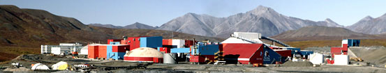
90 miles north of Kotzebue, is the world's largest zinc and lead mine, and provides over a quarter of the borough's wage and salary payroll. The Red Dog Mine CDP derives its name from the Red Dog mine, the world's largest source for zinc and a significant source of lead. Construction of the Red Dog mine began in 1987, after exploration revealed that the area was rich in metals. Although native populations have historically used the nearby area for seasonal food-gathering, there are no permanent residents at the mine or the port site.
The mine's workforce consists of about 460 employees and contractors, of which somewhat more than half will be on-site at any given time. At the mine, everyone stays in the single large housing unit, tucked in among the process buildings near the edge of the open pit, while a small portion of the work force stays at the port site. A 52-mile long haul road connects the mine to the mine's port site on the Chukchi Sea. The region is accessible only by air, except during the 100-day shipping season. Mine workers from remote villages in the region are ferried to the mine on small aircraft.
Population: 846
Eskimo village or tribe reported in 1842-44 by Lieutenant L. A. Zagoskin, Imperial Russian Navy (IRN), who spelled it "Chilivik." 1880 U.S. Census lists the Selawik people, i.e., "Selawigamute". Selawik post office was established in 1930. The people and the village probably took their name from the nearby lake or river. Around 1908, the village site had a small wooden schoolhouse and church. The village now has expanded across the Selawik River onto three banks, linked by bridges. Located on left bank of Selatwik River, 44 mi. NE of Elephant Point.
Location: Selawik is located at the mouth of the Selawik River where it empties into Selawik Lake, about 90 miles east of Kotzebue. It lies 670 miles northwest of Anchorage. The City is near the Selawik National Wildlife Refuge, a key breeding and resting spot for migratory waterfowl. Selawik is located in the Kotzebue Recording District. The community is located in the transitional climate zone. Temperatures average -10 to 15 during winter; 40 to 65 during summer. Temperature extremes have been recorded from -50 to 83. Snowfall averages 35 to 40 inches, with 10 inches of total precipitation per year. The Selawik River is navigable from early June to mid-October.
History: Lt. L.A. Zagoskin of the Imperial Russian Navy first reported the village in the 1840s as "Chilivik." Ivan Petroff counted 100 "Selawigamute" people in his 1880 census. Selawik is an Inupait name for a species of fish. Around 1908, the site had a small wooden schoolhouse and church. The village has continued to grow and has expanded across the Selawik River onto three banks, linked by bridges. Selawik incorporated as a First Class City in 1974, but in 1977, changed to a Second Class City government.
Culture: Selawik is an Inupiaq community active in traditional subsistence fishing and hunting. The sale or importation of alcohol is banned in the village.
Economy: Inhabitants of Selawik subsist mainly on whitefish, sheefish, caribou, moose, ducks, ptarmigan and berries. Occasionally, bartered seal and beluga whale supplement the diet. The primary employers in the community include the school, the City, the IRA, Maniilaq and three grocery stores. Handicrafts are made and sold locally and at gift shops in larger cities. Seasonal work is also found outside of Selawik at the Red Dog Mine, BLM firefighting or in lighterage operations. Four residents hold commercial fishing permits.
Sheshalik Former Eskimo village and summer camp, famous as a trading area for Eskimo and Indian, recorded as "Sesualik," in Captain F. W. Beechey's chart, dated 1831. In the 1880 Census, Petroff (1884, p. 4) listed "Sheshalegamute," population 100. Captain Hooper (1881, p. 44) published "She-shore-lik," and Lieutenant G. M. Stoney's manuscript map, dated 1883, shows "She-sur-are-lick." Located on Sheshalik Spit, 9 mi. NW of Kotzebue.
Population: 272
The village of Kochuk, later renamed Shungnak, was settled in the 1920s. The original village of Kobuk, settled in 1899 and situated about 10 miles upstream, was largely abandoned due to flooding. A few residents remain at Kobuk. The name "Shungnak" is derived from the Eskimo term "issingnak", which means jade, a stone found in the surrounding area.The first postmaster at Shungnak was Martin F. Moran, appointed September 24, 1903. A post office was established for a few months in 1934 and then again in 1946. Located on right bank of Kobuk River 85 mi. NE of Selawik.
Location: Shungnak is located on the west bank of the Kobuk River, about 150 miles east of Kotzebue. The original settlement was 10 miles further upstream at Kobuk. Shungnak is located in the Kotzebue Recording District. The area encompasses 8.4 sq. miles of land and 1.3 sq. miles of water. The community is located in the transitional climate zone. Temperatures average -10 to 15 °F during winter and 40 to 65 °F during summer. Temperature extremes have been recorded from -60 to 90 °F. Snowfall averages 80 inches, with 16 inches of total precipitation per year. The Kobuk River is navigable from the end of May to mid-October.
History: Founded in 1899 as a supply point for mining activities in the Cosmos Hills, this Inupiaq village was forced to move in the 1920s because of river erosion and flooding. The old site, 10 miles upstream, was renamed Kobuk by those who remained there. The new village was named "Kochuk" but later reverted to Shungnak. This name is derived from the Inupait word "Issingnak," which means jade, a stone found extensively throughout the surrounding hills. The city government was incorporated in 1967.
Culture: It is a traditional Inupiaq village with a subsistence lifestyle. The sale or importation of alcohol is banned in the village. High School students from Kobuk attend school in Shungnak.
Economy: Shungnak subsists mainly on fishing, seasonal employment, hunting, and trapping. Subsistence food sources include sheefish, whitefish, caribou, moose, ducks, and berries. Most full-time employment is with the school district, city, Maniilaq Association, two stores, and a lodge. BLM provides seasonal employment in firefighting, hiring over 30 residents each year. Shungnak also has a strong arts and crafts industry; residents make and sell finely-crafted baskets, masks, mukluks, parkas, hats, and mittens. The community wants to develop a visitor center, mini-mall, post office, and clinic complex at Dahl Creek.
Source: Unknown
Copyright © 1996 - The USGenWeb® Project, AKGenWeb, Northwest Arctic Borough

This page was last updated
06/19/2025