

Bristol Bay Borough &
Dillingham Census Area
AKGenWeb

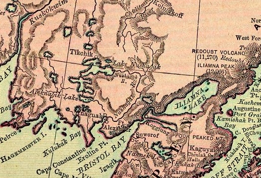
1895 Rand McNally Atlas
Courtesy of Pam Reitsch
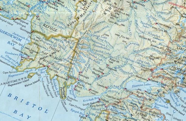
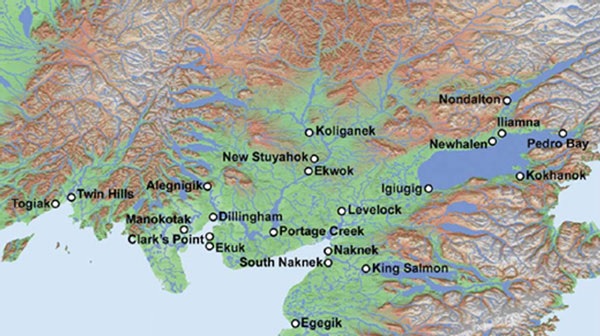
Modern Detail Map
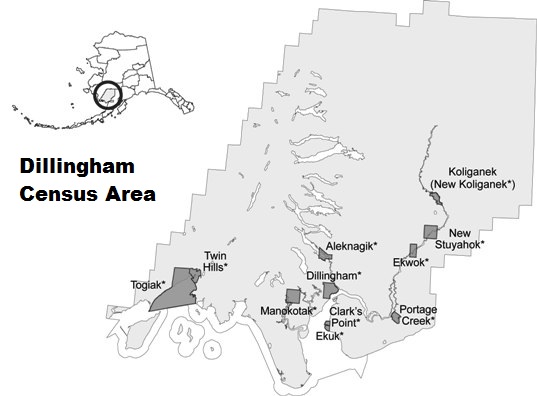
Dillingham Census Area
Located on right bank of Nushagak River at mouth of Mulchatna River, 65 mi. NE of Dillingham. Akokpak was the village's Eskimo name reported in 1925 by U.S. Bureau of Fisheries (USBF).
Located on SE shore of Lake Aleknagik, 17 mi. N of Dillingham; Kilbuck-Kuskokwim Mts. There were two villages, both named for the lake, the other being at the head of Lake Aleknagik has disappeared. Located in Dillingham Census Area. The Eskimo village was recorded as "Sel(eniye) Imyak" by Captain Tebenkov (1852, map 4), Imperial Russian Navy (IRN).
Description:
Located on left bank of Ood River, 7 mi. N of Dillingham. The Eskimo village reported by Ivan Petroff in the 10th Census in 1880.
Located 1 mile ESE of Cheching Mtn., 12 mi. SE of mouth of Ooksokwak River and 95 mi. SW of Bethel, Yukon-Kuskokwim Delta. Cheching was the village's Eskimo name reported in 1949 by U.S. Coast and Geodetic Survey (USC&GS) with a 1950 population of 54 people.
Located in Dillingham Census Area at Clarks Point on east shore of Nushagak Bay, 14 miles south of the city of Dillingham. The community was established in the 1920s as a cannery. The community was named for John Clark, who was the manager of the Alaska Commercial Company store at Nushagak Bay (Alaska Division of Community & Regional Affairs, Community Database, 2009). The Clarks Point post office was established in 1935. This is the site of the former Eskimo village or camp of "Sturarok," population 7, recorded in the 1890 Census (1893, p. 95). The population was 25 in 1930; 22 in 1939; and 128 in 1950.
Dillingham is located in Dillingham Census Area, at the south coast of Snag Point, head of Nushagak Bay, and at the mouth of the Wood and Nushagak Rivers in Bristol Bay. It is just south of Wood-Tikchik State Park. Dillingham is located 327 miles southwest of Anchorage and is surrounded by rolling tundra with ridges of spruce and birch trees.
Named in 1904 for William Paul Dillingham, 1843-1923, Governor of Vermont, 1888-90 and U.S. Senator, 1903-23. This location was originally occupied by a Eskimo village recorded as "Ah-lek-nug-uk," by Ivan Petroff in the 1880 Census and as "Kanakanak" in the 1890 Census; it was also known as "Chogim." The post office of Killingham was extablished on Snag Point in 1904, About 1944 the name "Dillingham" was transferred to this site. Dillingham is now the principal settlement.
Wood-Tikchik State Park is spread over 1.6 million acres and named for its two separate systems of large, interconnected clear-water lakes. Bordered by the Nushagak lowlands on the east and the Wood River Mountains to the west, the two systems of lakes span a variety of terrain and are renowned for their diverse beauty. Other than 11 fishing and hunting lodges in and around the park, Wood-Tikchik is an undeveloped wilderness that attracts kayakers, canoers, rafters and boaters. Visitors are usually totally self-sufficient and reach the park by air taxi from Dillingham or charter boat from the village of Aleknagik on Lake Aleknagik, 25 miles north of Dillingham and connected to the city by road.
Also famous for walruses is Walrus Islands State Game Sanctuary, a group of seven craggy islands and their adjacent waters located in northern Bristol Bay southwest of Dillingham. Best know among the Walrus Islands is Round Island, the largest haul-out grounds in Alaska, where each summer 15,000 male walruses haul out on exposed, rocky beaches to stake out their territory for the upcoming mating season. Other wildlife is also plentiful on this remote island including Steller sea lions, migrating whales, orcas, puffins and thousands of other seabirds.
Dillingham is also the hub for many of the air taxis that operate within Togiak National Wildlife Refuge. The 4.7-million-acre refuge encompasses pristine rivers, clear mountain lakes and steep sloped mountains, stretching from the restless Bering Sea to the treeless tundra uplands of the Ahklun and Wood River Mountains. The main activities in the refuge are float trips and sport fishing as Togiak offers some of the finest salmon and trout fishing in Alaska as habitat to all five Pacific salmon species. The refuge also provides habitat for at least 201 staging, migrating or breeding bird species while brown bear, moose and caribou attract sport hunters to the area. Along Togiak's coastline up to 12,000 male walrus may haul out on Cape Pierce at one time.
Was located 2 miles N of Togiak Village, on right bank of Togiak River, 44 mi. E of Goodnews, Kilbuck-Kuskokwim Mts.
Was locatedon right bank of Togiak River, 45 mi. E of Goodnews, Kilbuck-Kuskokwim Mts.
Located in Dillingham Census Area, on E shore of Nushagak Bay, 16 mi. S of Dillingham. Population 40.
Located in Dillingham Census Area, on the right bank of the Nushagak River, at junction of Klutuk Creek, 42 mi NE of Dillingham.
Located on left bank of Nushagak River, 5 mi. S of Nunachuak and 62 mi. NE of Dillingham. Eskimo camp or small village reported in 1910 by H. C. Fassett, U.S. Bureau of Fisheries (USBF), as "Ah-lai-luk-ah." The present spelling was first used in 1925 by U.S. Bureau of Fisheries (USBF). The site is now abandoned.
Located S of mouth of Igushik River, 30 mi. SW of Dillingham. The Eskimo village listed in the 1880 U. S. census with a population of 74; 28 in 1930; and 16 in 1940.
Located at head of Nushagak Bay, 2 mi. NE of Nushagak and 6 mi. SE of Dillingham. The Eskimo village was reported by Ivan Petroff in 1880 Census. Its population in 1880 was 142; in 1890, 54; it is now abandoned.
Located on right bank of Togiak River, 1.3 mi. E of Nayorurun River, 57 mi. NE of Goodnews, Kilbuck-Kuskokwim Mts. Former Eskimo village or camp mentioned by Ivan Petroff in the 1880 census as "Kissiak;" published in 1884 as "Kissaiakh." It was recorded "Kashaiyagamut" on an 1898 field sheet by W. S. Post, but was published as "Kashaiagamut" (Spurr, 1900, map 10), U.S. Geological Survey (USGS). The population in 1880 was 181; in 1940, 33.
Located on right bank of Togiak River, 5 mi. SW of Kashiagamiut and 50 mi. ENE of Goodnews, Kilbuck-Kuskokwim Mts. This Eskimo village, which had two dance houses, was first mentioned by Ivan Petroff in the 10th U.S. Census. The name means "Kiassian people." Its population in 1880 was 615, in 1890 it was 50; it is now abandoned.
Located in Bristol Bay Borough on the north bank of the Naknek River on the Alaska Peninsula, about 16 miles upriver from Naknek. (The two communities are connected by the Alaska Peninsula Highway, built in 1949.) It was the site of a military base during World War II. The King Salmon post office was established in 1949 at King Salmon Air Force Base (closed about 1994). It is now a service center for the commercial red salmon and sport fishing industries. The wide open, often treeless landscape that surrounds King Salmon gives it a quiet, edge-of-the-world appeal. While inaccessible by road, during the summer months King Salmon can also be reached by jet service from Anchorage.
King Salmon provides a gateway to Katmai National Park and Preserve, which is renowned for the Valley of 10,000 Smokes, the moon-like landscape of which is the result of the Mount Katmai eruption. The 4.2-million-acre national park is a popular place for bear viewing.
King Salmon is also the gateway to the numerous fly-in fishing and adventure camps and lodges on the Alaska Peninsula as well as wildlife viewing expeditions headed to Becharof National Wildlife Refuge, Alaska Peninsula National Wildlife Refuge, and McNeil River State Game Sanctuary.
Located on E bank of Kvichak River at Graveyard Point, on Alaska Peninsula, 9 mi. N of Naknek. The Eskimo village listed by Ivan Petroff in the 1880 Census with a population of 29; 133 in 1890; and 533 in 1900. Its increase in population was due to the establishment of several canneries. The Koggiung post office operated from 1935 to 1946.
Located on right bank of Nushagak River, near mouth of Kokwok River, 36 mi. NE of Dillingham. The Eskimo village or camp mentioned by Ivan Petroff in the 10th Census of 1880 as "Kukuak." It was called "Kok-wok-ha-mut," meaning "Kok-wok people," on a 1910 manuscript map by H. C. Fasset, U.S. Bureau of Fisheries (USBF). F. H. Waskey, a local resident, reported in 1931 that the name "Kokwok" was nearer the Eskimo pronunciation than "Kakuak or "Kakwok." The population of the village was 104 in 1880; 45 in 1890. The village is now abandoned.
Located in Dillingham Census Area, on left bank of Nushagak River, 65 mi. NE of Dillingham. Population 100,
Located on N coast of Alaska Peninsula, 3.5 mi. NW of Naknek. Name published by U.S. Coast and Geodetic Survey (USC&GS) in 1947 Coast Pilot (p. 521). This village is the site of a Libby, McNeill, and Libby Co. cannery.
Located in Dillingham Census Area, on left bank of Igushik River, 22 mi. SW of Dillingham, Kilbuck-Kuskokwim Mts. The Eskimo village reported in 1948 by USC&GS. Its population was 120 in 1950; a post office was established here in 1960 (Ricks, 1965, p. 41).
Located N of Aleknagik, at SE end of Lake aleknagik, 18 mi. N of Dillingham, Kilbuck-Kuskokwim Mts. This was originally an Eskimo village called "I-gi-ahk", recorded on a 1910 manuscript map by H. C. Fasset, U.S. Bureau of Fisheries (USBF). The local name "Mosquito Point" was reported in 1937 by U.S. Geological Survey (USGS) and published by Mertie (1938, pl. 1), U.S. Geological Survey (USGS). In 1937 this village consisted of 40 white people. A territorial school was there. It is no longer permanently occupied.
Located on the north bank of the Naknek River, near its mouth, adjacent to the northeast end of Bristol Bay and the world’s richest sockeye salmon fishery, 56 miles SE of Dillingham. The abundance of salmon attracted Yup'ik Eskimos and Athabascan Indians to the region more than 6,000 years ago and Russians traders by 1821. The Eskimo village was reported about 1821 by Captain Lieutenant M. N. Vasiliev, Imperial Russian Navy (IRN), who gave its name as "Naugeik." Sarichev (1826, map 3), Imperial Russian Navy (IRN), reported it as "Naugvik." "Naknek" by Captain Tebenkov (1852, map 4), Imperial Russian Navy (IRN) built a post called "Fort Suvarov" at or near the village, named after the nearby point of land. Village name as "Kinghiak."
In 1890, the first cannery opened on the Naknek River. By 1900, there were approximately 12 canneries in Bristol Bay. The Homestead Act enabled canneries to acquire land for their plants and also make land available to other institutions and individuals. The parcel owned by the Russian Orthodox Church on the north side of the Naknek River was the first land recorded in Naknek. Squatters built shelters on the church property and were eventually sold lots in what became the center of Naknek. The Russian Orthodox St. John the Baptist Chapel in Naknek, reportedly constructed in 1886, is on the National Register of Historic Places.
Naknek post office was established in 1907.
Population 111 in 1920; 173 in 1930; 152 in 1939; and 174 in 1950.
Naknek is a small community of 554 residents accessible via road through King Salmon. Fishing is Naknek’s lifeblood and supports six salmon processors that draw several thousand seasonal workers each summer. Naknek, the site of the world’s largest sockeye salmon run from mid-June to the end of July.
Naknek is also home to the Bristol Bay Historical Museum, featuring archaeology, history and Native culture, and documents Naknek's history as one of the largest commercial salmon fishing and canning headquarters in the world. The museum building is the original Fisherman's Hall, an early meeting place for fishermen.
Located on right bank of Nushagak River, 3 mi. SW of Dillingham. Named about 1944 for Senator Knute Nelson, 1843-1923, Governor of Minnesota 1893-95, and U.S. Senator, 1895-1923. "Dillingham," and an Eskimo village called "Keek-sel-hak" was recorded on a 1910 manuscript map by H. C. Fassett, U.S. Bureau of Fisheries (USBF). 1944 the name "Dillingham" was transferred to Snag Point where the Dillingham post office had been since 1904; the name "Nelsonville" came into use about this time.
Located in Dillingham Census Area, on the right bank of Nushagak River, 10 mi. NE of Ekwok, and 52 mi. NE of Dillingham. Originally the site of the Eskimo village of "Stuyarok", New Stuyahok was listed in the 1950 Census, population 88. New Stuyahok post office was established in 1961. Population 145.
Located on right bank of Nayorurun River, 5 mi. N of its junction with Togiak River and 56 mi. NE of Goodnews, Kilbuck-Kuskokwim Mts. Former Eskimo village reported by Ivan Petroff in the 10th census in 1880.
Located on left bank of Nushagak River below its junction with Nunachuak Creek, 64 mi. NE of Dillingham. The Eskimo village reported in the 1930 Census with a population of 32 and in 1940, 50.
Located at Nushagak Point, on E shore of Nushagak Bay, 6 mi. S of Dillingham. The former Eskimo village established as a trading post about 1819, called by the Russians "Aleksandrovsk," probably for Alexander Baranov, Governor, under whose orders the post was founded. The transfer of Alaska to the United States the settlement was referred to as "Fort" or "Redoubt Alexander" until a post office, called "Nushagak" after the river, was established in 1899, 1.5 mi. N of here at Carmel. (Ricks, 1965, p. 48). Population 268 in 1890; 74 in 1910; 16 in 1920; 43 in 1930; and 7 in 1958. Nushagak was the principal village of several located nearby. In 1918, an epidemic (probably measles) decimated the population.
Located in Dillingham Census Area, at the confluence of Portage Creek with the Nushagak River. Population in 2010 was down to only 2.
Located on S bank of Naknek River, on Alaska Peninsula, 5 mi. ESE of Naknek. Name published in 1962 by U.S. Geological Survey (USGS). There is another Savonoski near the east end of Iliuk Arm Naknek Lake.
Located on S bank of Naknek River, on Alaska Peninsula, 1 mi. SE of Naknek. A Native village of Qinuyana was once located on the site where it developed. Many of the villagers came to South Naknek from the villages of New and Old Savanoski. Old Savanoski is located near the "Valley of Ten Thousand Smokes." It was abandoned after the 1912 Katmai volcanic eruption. An Eskimo and Aleut village listed in the 1880 Census with a population (including Kingiak) of 192; 93 in 1890. The South Naknek post office was established in 1937.
Located on N shore of Tikchik Lake, E of Tikchik River and 65 mi. N of Dillingham, Kilbuck-Kuskokwim Mts. An Eskimo village reported with a population of 38 by Ivan Petroff in the 10th Census in 1880; recorded as "Tuk-shik-ha-mut" on a 1910 manuscript map by H. C. Fasset, U.S. Bureau of Fisheries (USBF). Suffered "great sickness" in 1899-1900 which decimated the population.
Located in Dillingham Census Area, at head of Togaik Bay, 2 mi. W of mouth of Togiak River and 43 mi. E of Goodnews, Kilbuck-Kuskokwim Mts. The Eskimo village name reported as "S(elo) Tugiatak," or "Tugiak Village," by Lieutenant Sarichev (1826, map 3); and as "S(leo) Tugiak" by Captain Tebenkov (1852, map 4) Imperial Russian Navy (IRN). In 1880 Petroff (1881, p. 48) recorded two villages, "Togiagamute," population 276 (94 in 1890) and "Togiak Station," population 28 (14 in 1890), both located, on his map, E of the mouth of the river, about 7 mi. apart. The southernmost, "Togiak Station" has been called "Owens," named, according to Frank Waskey, local trader and prospector for Johnny Owens who operated this important trading post. "Togiak Village" was published in the 1947 Coast Pilot (p. 530). The population was 71 in 1945 and 108 in 1950. Togiak was incorporated as a city on June 10, 1969.
Located in Dillingham Census Area, at the northeast end of Togiak Bay and adjacent to the city of Togiak. The original settlement of Togiak (then Togiagamute) was on the northeast side of Togiak Bay. In the early 20th century, many residents removed to the northwest side of the bay to establish the "new" Togiak. The population was 74 at the 2010 census.
Located in Dillingham Census Area, on left bank of Ungalikthluk River, 12 miles southeast of Togiak, Kilbuck-Kuskokwim Mountains. Ivan Petroff showed a village symbol in this area on an 1881 map, but he failed to give a name. The Eskimo name was reported in 1948 by U.S. Coast and Geodetic Survey (USC&GS).
Located at the junction of Wood and Nushagak Rivers, 2 mi. NE of Dillingham. It is the site of an Eskimo village of "Ah-lek-nug-uk," which was recorded on a 1910 manuscript map by H. C. Fassett, U.S. Bureau of Fisheries (USBF).
Sources: Unknown
Copyright © 1996 - The USGenWeb® Project, AKGenWeb, Bristol Bay Borough & Dillingham Census Area

This page was last updated
06/18/2025