
![]()

MAPS
TOWNS, VILLAGES AND POPULATED PLACES
Source: USGS and Wikipedia
Alpine is a census-designated place (CDP) in North Slope Borough, Alaska, United States. The population was 0 at the 2000 census. Most employees work a two week on and two week off work schedule. Alpine is the site of a major oil drilling and production operation operated by Conoco Phillips. Oil was discovered in the Alpine area in 1996. Alpine currently serves as an oil production field producing roughly 130,000 barrels of oil daily.
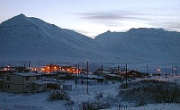 Anaktuvuk Pass is a city and mountain pass in North
Slope Borough, Alaska, United States. The population was 249 at the 2007 Census Bureau estimate. Anaktuvuk Pass was
named after the Anaktuvik River. Anaktuvuk means place of caribou droppings in the Inupiaq
language. Anaktuvuk Pass is slightly north of the Brooks Range on the divide between the Anaktuvuk and the John Rivers, located at an
elevation of 2,200 ft (670 m). Anaktuvuk Pass is the last remaining settlement of the Nunamiut (People of the Land) Inupiat Eskimo in
Alaska.
Anaktuvuk Pass is a city and mountain pass in North
Slope Borough, Alaska, United States. The population was 249 at the 2007 Census Bureau estimate. Anaktuvuk Pass was
named after the Anaktuvik River. Anaktuvuk means place of caribou droppings in the Inupiaq
language. Anaktuvuk Pass is slightly north of the Brooks Range on the divide between the Anaktuvuk and the John Rivers, located at an
elevation of 2,200 ft (670 m). Anaktuvuk Pass is the last remaining settlement of the Nunamiut (People of the Land) Inupiat Eskimo in
Alaska.
 Name is an Inupiaq Eskimo word meaning "the place to dig the
rock that burns," in reference to a large coal seam located here according to 1923 fieldsheet by E. C. Guerin, U.S.
Geological Survey (USGS). Another Eskimo name, "Tikiluk," was reported in 1951. A post office was established there in 1951 with
the name "Meade River." It was discontinued in 1957. Located on W bank of the Meade River near Imarkrak Lake, 62 miles ESE of
Wainwright and 59 miles SSW of Barrow, Arctic Plain.
Name is an Inupiaq Eskimo word meaning "the place to dig the
rock that burns," in reference to a large coal seam located here according to 1923 fieldsheet by E. C. Guerin, U.S.
Geological Survey (USGS). Another Eskimo name, "Tikiluk," was reported in 1951. A post office was established there in 1951 with
the name "Meade River." It was discontinued in 1957. Located on W bank of the Meade River near Imarkrak Lake, 62 miles ESE of
Wainwright and 59 miles SSW of Barrow, Arctic Plain.
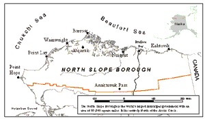
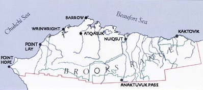
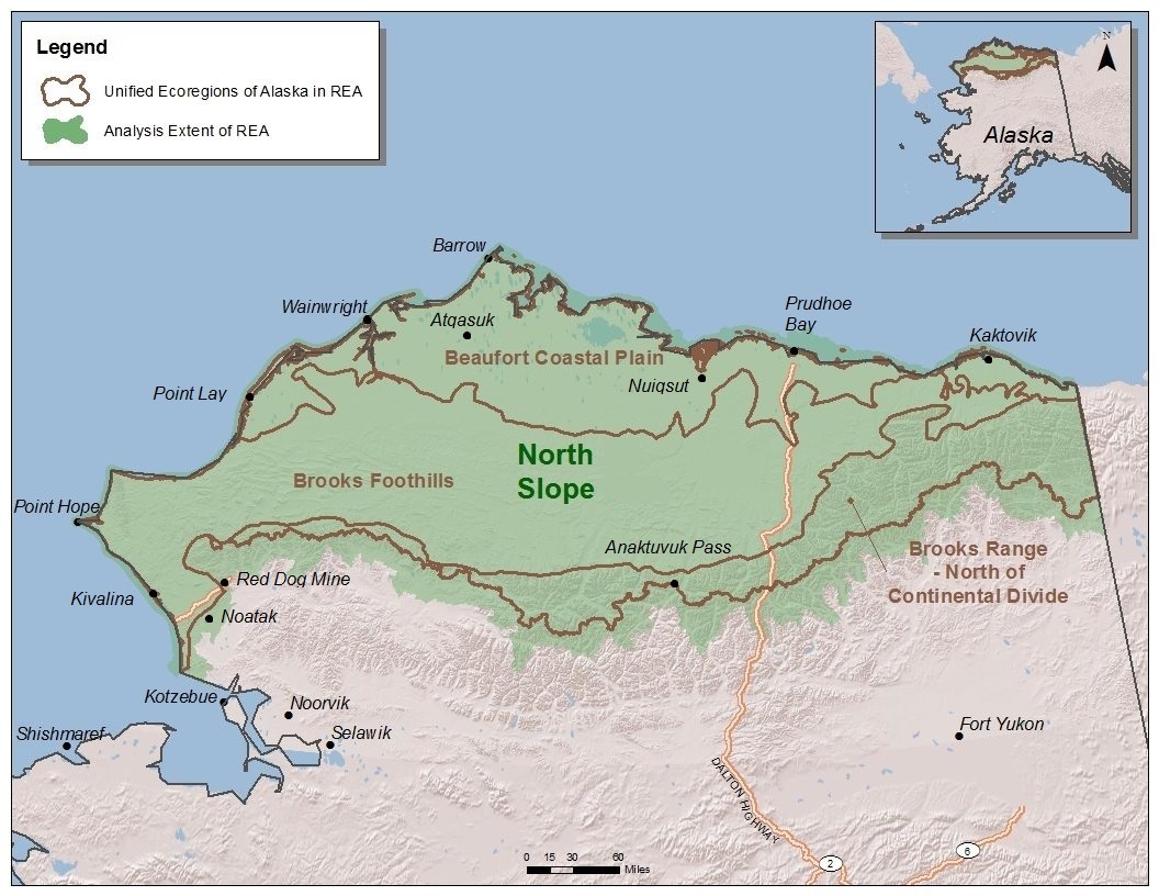
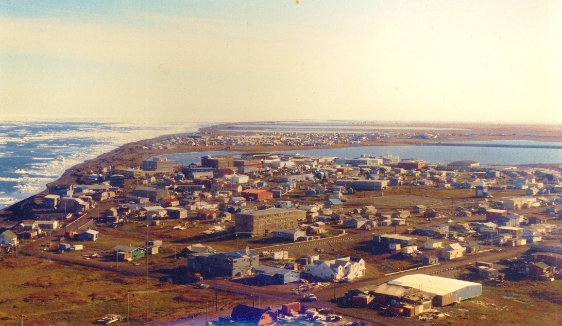
 Barrow is borough seat of the North Slope Borough. It is one of the
northernmost cities in the world. Nearby Point Barrow is the northernmost point of the United States.
Barrow is borough seat of the North Slope Borough. It is one of the
northernmost cities in the world. Nearby Point Barrow is the northernmost point of the United States.
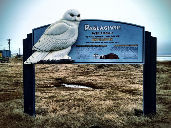
The city derived its name from Point Barrow, which was named by Frederick William Beechey in 1825 for Sir John Barrow of the British Admiralty. The location has been home to Native Inupiat Eskimo people for over 1,000 years under the name Ukpeagvik or "place where snowy owls are hunted" On November 18 or 19 the sun goes down, and remains below the horizon for about 65 days until it re-appears, normally on January 22 or January 23. During the first half of the polar night there is a decreasing amount of twilight each day, and on the winter solstice, December 21 or December 22, civil twilight in Barrow lasts for a mere 3 hours. Source: Wikipedia
Barrow. Pop 550. A p o, village and U S signal station in the extreme northern
part of Alaska also known as Point Barrow and Utkiavik, 600 miles ne of Kotzebue
and 800 ne of Nome. Mail is received four times a year and oftener when it can
be carried without compensation from the government. Yearly boat to Name and
Seattle.
Brower Chas, mgr whaling station
Cape Smythe Whaling &
Trading Co, whaling and gen mdse
Cram D W, Postmaster and U S
Commissioner
Kangusik & Co, gen mdse and whaling
Takpuk & Co,
reindeer and whaling.
Source: 1915-16 Alaska-Yukon Gazetteer and Business Directory,
R. L. Polk & Co., page 135.
Named for Charles D. Brower, who came to the Barrow area in 1886 as head of a whaling station. He later established a trading post. This locality is near the site of the U.S. Polar Station established by Lieutenant P. H. Ray in 1881. Adjacent to Barrow on Chukchi Sea coast, NE of Barrow, Arctic Plain.
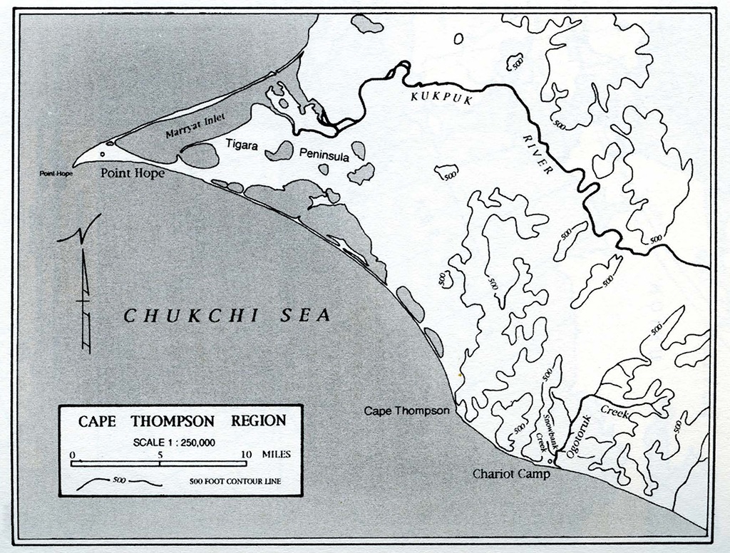
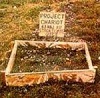 Chariot is a populated place on the coast of the Chukchi
Sea in the western part of North Slope Borough in the U.S. state of Alaska. It is located Near the mouth of Ogotoruk Creek in the
Ogotoruk Valley on the coast of the Chukchi Sea, 6.5 mi ESE of Cape Thompson, Arctic Slope.Named about 1962 for Project Chariot by
personnel of the project. The name probably refers to a headquarters building on the site. Point Hope residents successfully opposed
Operation Chariot (1958), which would have involved atmospheric thermonuclear detonations some 30 miles from the village.
Chariot is a populated place on the coast of the Chukchi
Sea in the western part of North Slope Borough in the U.S. state of Alaska. It is located Near the mouth of Ogotoruk Creek in the
Ogotoruk Valley on the coast of the Chukchi Sea, 6.5 mi ESE of Cape Thompson, Arctic Slope.Named about 1962 for Project Chariot by
personnel of the project. The name probably refers to a headquarters building on the site. Point Hope residents successfully opposed
Operation Chariot (1958), which would have involved atmospheric thermonuclear detonations some 30 miles from the village.
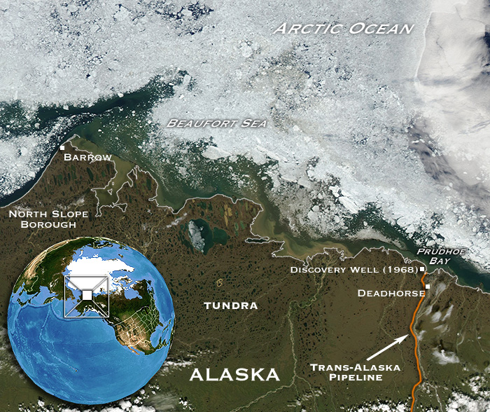
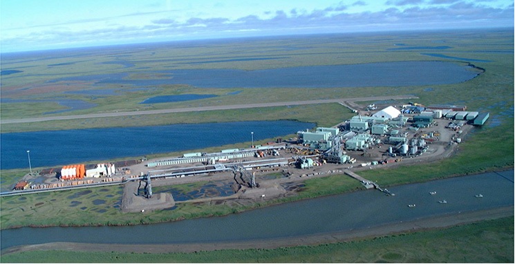
Deadhorse is an unincorporated community in North Slope Borough, Alaska, United States, along the North Slope near the Arctic Ocean. The town consists mainly of facilities for the workers and companies that operate at the nearby Prudhoe Bay oil fields. Deadhorse is accessible via the Dalton Highway from Fairbanks, or the Deadhorse Airport. Limited accommodations are also available for tourists. Companies with facilities in Deadhorse service Prudhoe Bay, nearby oil fields, and the Trans-Alaska Pipeline System (TAPS), which brings oil from Prudhoe Bay to Valdez on the south-central Alaska coast. Facilities in Deadhorse are built entirely on man-made gravel pads and usually consist of pre-fabricated modules shipped to Deadhorse via barge or air cargo.
Deadhorse is featured on the third season of "Ice Road Truckers," an American reality television series airing on the History Channel.[1] The show, which dramatizes trucking on the Dalton Highway, often features truckers transporting equipment to the oil companies located in or around the Prudhoe Bay area.[2] The Prudhoe Bay, Alaska area was developed to house personnel, provide support for drilling operations, and to transport oil to the Alaskan pipeline.[3] Prior to 1977, oil seeps on the Arctic coastal plain had caught the attention of the U.S. petroleum interests.[3] The U.S. Navy drilled for oil between 1944 and 1953 with little success.[3] However, in 1967, after several attempts at drilling for oil, oil company mergers, and competitive bidding for state lease sales, the Prudhoe Bay oil field was discovered.[3] Sources conflict on the origin of the area's name.The most cited theory appears to be that the area takes its name from a local business prominent in the late 1960s and 1970s, the "Dead Horse Haulers" trucking company.Tourists traveling to Deadhorse and Prudhoe Bay typically take tour buses from Fairbanks via the James Dalton Highway, a two-day journey with an overnight stop in Coldfoot. During the summer months, visitors can access the Arctic Ocean during its summer thaw, as well as experience the midnight sun due to Deadhorse's location above the Arctic Circle. In winter, the opposite phenomenon of polar night occurs.Because alcoholic beverages are not sold in Deadhorse, a humorous slogan for the town is "All that far and still no bar."
Named for Thomas Gordon, who came to the N coast of Alaska from Scotland in 1888 and became a trader. Site of trading post on NE shore of Demarcation Bay, 2.5 mi. E of Demarcation Point, Arctic Plain. Abandoned
Kaktovik is a city in North Slope Borough, Alaska. Until the late nineteenth century Barter Island was a major trade center for the Inupiat and was especially important as a bartering place for Inupiat from Alaska and Inuit from Canada. Kaktovik was traditional fishing place — Kaktovik means Seining Place—that has a large pond of good fresh water on high ground. It had no permanent settlers until people from other parts of Barter Island and northern Alaska moved to the area around the construction of a runway and Distant Early Warning Line station in the 1950s. The area was incorporated as the City of Kaktovik in 1971. Due to Kaktovik's isolation, the village has maintained its Inupiat Eskimo traditions. Subsistence is highly dependent upon the hunting of caribou and whale.
Site of Eskimo village, on Chukchi Sea coast, 22.5 km (14 mi) SW of Wainwright; Arctic Plain. This Eskimo name has been variously spelled by authorities for more than 100 years. in Russian by Lieutenant L. A. Zagoskin, Imperial Russian Navy (IRN), in 1842-44, as "Kylyamigtagvik," and then in 1861 by P. Tikhmeniev as "S(elenie) Kilametagagmyut," or "Kilametagag people's village," Census recorded the name as "Kolumakturook." Ray's "Barrow Expedition" told Marcus Baker in 1890 that the name is probably derived from that of a throwing weapon like a sling or bola. and "Kilauwitawinmium" (p. 44), and in a letter "Ke-lev-a-tow-tin." (Abandoned)
This locality is an Eskimo campsite reported by USGS in 1951, on coast of Beaufort Sea, E of Pitt Point, 88 mi. SE of Barrow; Arctic Plain.
Site of an Eskimo village, on Chukchi Sea coast, on Kasegaluk Lagoon, 21 mi. SW of Wainwright, Arctic Plain. Eskimo name recorded as "Me-lik-tahk-vik" by Archdeacon Stuck (1920, p. 192). Orth was told at Wainwright in 1965 that this is a place where canoes are built. "Mitlik" means "adz", or "place where the adz is used." (Abandoned)
Site of Eskimo village on coast of Chukchi Sea, on point of land, near S end of Kasegaluk Lagoon, 19 mi. S of Point Lay; Arctic Plain. Eskimo name reported by U.S. Geological Survey (USGS) in 1923. According to a U.S. Coast and Geodetic Survey (USC&GS) field report this place (Neakok) was an old whaling post, now abandoned, consisting in 1949 of two old buildings. The name means "head". (Abandoned)
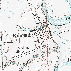
Nuiqsut is in the North Slope Borough on the Nechelik Channel, about 35 miles from the Beaufort Sea coast. The native persons of the village are Inupiat Eskimo. The village was re-established in the early 1970s when these persons moved to the region from Barrow, Alaska. For one year the residents lived in tents while housing was built. These original residents were the first to receive dividends from the oil companies in exchange for land use. The dividends are passed from the original shareholders on to the community member of their choice (often parent to child). Nuiqsut is located in the midst of a vast quantity of oil. Many major oil companies have oil facilities in the region (ConocoPhillips, BP, etc.). The relationship with the community of Nuiqsut is such that the oil company using the land, considered to be the property of the native Nuiqsut residents (Inupiat Eskimos), pay dividends to residents in exchange for use of the land. For many native residents the dividends are the primary, or only, source of income. Native traditions such as hunting (whale, caribou, fox, ptarmigan, etc.) and the making of native clothes and crafts continues, although the influence of modern society has reduced both need and interest in these activities to some degree. The traditional whale hunted by the whalers of Nuiqsut is the Bowhead Whale.
Former Eskimo village reported in 1853 by John Simpson (1885, p. 237), who wrote, signifies emphatically The Point. The population was 309 and the village consisted of 54 inhabited houses. In 1882 Lieutenant Ray (1885, p. 38), USA, reported a population of 150. Located on Arctic Coast, at Point Barrow, Arctic Plain.
Site of an Eskimo village, on barrier bar between the Chukchi Sea and W end of Peard Bay, 27 mi. NE of Wainwright, Arctic Plain. Pingasagruk was a very large old settlement that has long been abandoned. According to the natives, this place was called 'Pingashugaruk,' and several hundred people had lived there (Smith and Mertie, 1930, p. 105). (abandoned)
Point Hope town is located in the Point Hope landhead, at the NW end of the Lisburne Peninsula, on the Chukchi Sea coast, 40 mi. SW of Cape Lisburne. The descriptive Inuit name of the place, "Tikarakh" or "Tikigaq" commonly spelled "Tiagara," means "forefinger". It was recorded as "Tiekagagmiut" in 1861 by P. Tikhmeniev Wich of the Russian Hydrographic Department and on Russian Chart 1495 it became "Tiekaga". This ancient village site was advantageous, because the protrusion of Point Hope into the sea brought the whales close to the shore. At Tikigaq, they built semi-subterranean houses using mainly whalebone and driftwood. Point Hope is one of the oldest continually occupied sites in North America. While some of the earlier dwellings have been lost to erosion as the island shrinks, it still provides a welter of valuable information to archaeologists on how early Eskimos survived in their harsh environment. The Tikigaq site is "by far the most extensive and complete one-period site yet discovered and described in the entire circumpolar region." - Helge Larsen [4]
The first recorded Europeans to sight this cape were Russian explorers Mikhail Vasiliev and Gleb Shishmaryov of the Imperial Russian Navy on ships Otkrietie and Blagonamierennie. Vasiliev and Shishmaryov named this landhead Mys Golovnina, after Vice Admiral Vasily Golovnin (1776-1831). The cape at Point Hope was renamed by Captain Frederick William Beechey of the Royal Navy, who wrote in August 2, 1826: "I named it Point Hope in compliment to Sir William Johnstone Hope". Point Hope residents successfully opposed Operation Chariot (1958), which would have involved atmospheric thermonuclear detonations some 30 miles from the village.
The village has an annual hunt of Beluga Whales within the Kasegaluk Lagoon.
On the Fourth of July, a parade runs through town led by the fire engines and ambulances of the town's modern fire department. The Eskimo name for the village was Kali, which means "mound", after a raised area on the barrier island where the old village stood. The school and fire department bear the name Kali. Until recently, a cluster of radar dishes existed near Point Lay. These were a part of the Distant Early Warning Line, a system of defensive radar installations built during the Cold War. The station was decommissioned during the 1990s, and the radar dishes were dismantled sometime between 2004 and 2006.
Prudhoe Bay is a census-designated place (CDP) located in North Slope Borough in the U.S. state of Alaska. As of the 2000 census, the population of the CDP was 5 people; however, at any given time several thousand transient workers support the Prudhoe Bay oil field which is the largest oilfield in the United States. The airport, lodging, and general store are located at Deadhorse; the rigs and processing facilities are located on scattered gravel pads laid atop the tundra. Only during winter is the surface hard enough to support heavy equipment; new construction happens then. Prudhoe Bay is the unofficial northern terminus of the Pan-American Highway. A few tourists, arriving by bus after a two-day ride up the Dalton Highway from Fairbanks, come to see the tundra, the Arctic Ocean, and the midnight sun, staying in lodgings assembled from modular buildings. Prudhoe Bay was named in 1826 by British explorer Sir John Franklin after his classmate Captain Algernon Percy, Baron Prudhoe. Sagwon Sagwon is a small unincorporated community in North Slope Borough, Alaska, United States. It is above the Arctic Circle. It is known for the Gallagher Flint Station Archeological Site which was discovered during the construction of the Trans-Alaska Pipeline.
Umiat is an unincorporated community in North Slope Borough, Alaska, United States. It is located 140 miles southwest of Deadhorse in the Arctic Circle. The town is not accessible by road or rail. In 1944, the Naval Oil Reserve was set up and it later became an air force base, which is now closed. It is known as one of the coldest places in the US. Umiat has since become a center in the summer for research by the BLM and USGS, vital to the study of Global Climate change. Research also goes on in the impact that development has on the Artic tundra. As the NPRA is managed by BLM, they watch very closely to the impact that the ice roads and Ice drilling pads have on the various plantlife in the area. Umiat has no permanent residents and is in actuality a camp and fuel stop for aircraft operating in the area. The camp is run by a locally owned company that provides oilfield services in many different spots. Their crew consists in the summer of approximately 10 people who work on a two weeks on two weeks off schedule. At any given time, there are between 20 to 30 people lodged and fed there and have had as many as five helicopter working there. These aircraft and the people that work there begin showing up in the Middle of May and continue until the middle of September. All there have access to internet and all news and entertainment by satellite.
Wainwright or Ulguniq or Kuuq is a city in North Slope Borough, Alaska, United States. At the 2000 census the population was 546, making it the second largest city in the North Slope Borough. The community was named after Wainwright Lagoon, which in turn was named an officer under Capt. F.W. Beechey, Lt. John Wainwright, who both discovered the lagoon in 1826. Wainwright was founded in 1904. The people of Wainwright are Inupiat Eskimos who rely on subsistence hunting based primarily on whales and caribou. A primary focus of subsistence is the annual hunting of bowhead whales. Whaling occurrs during the spring in Wainwright and involves hunting bowheads as they pass through open leads in the ice.
Wevok is a former Inuit village in the western part of North Slope Borough in the U.S. state of Alaska. Its name is derived from the Inuit name of Cape Lisburne, which lies only 5 Km to the west.