

Nome Census Area
AKGenWeb

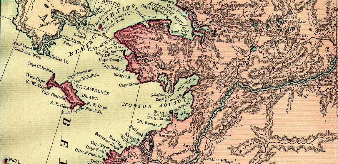
1895 Rand McNally Atlas
Courtesy of Pam Reitsch
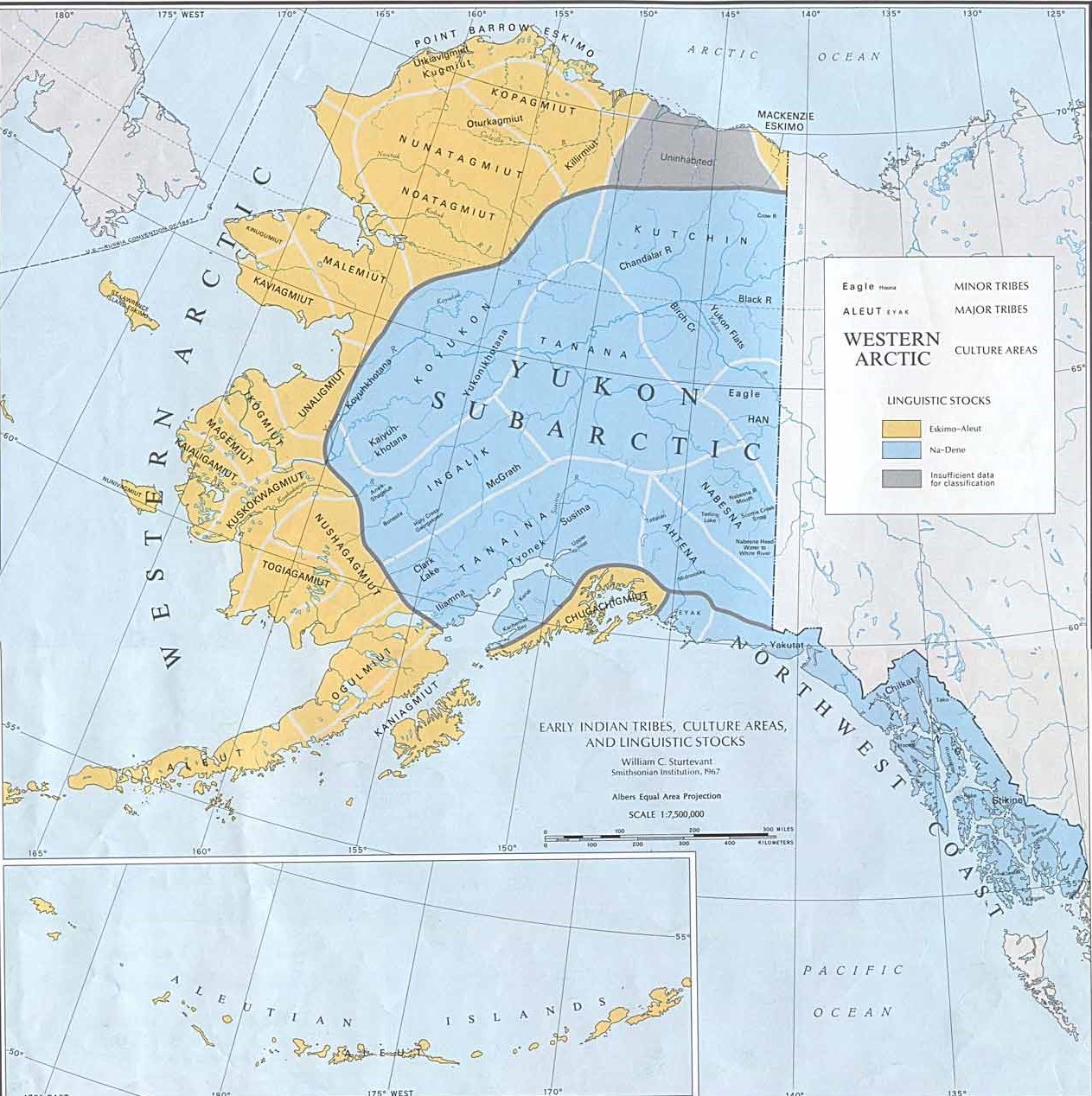
Western Arctic Culture Areas
Smithsonian Map
Gold Rush
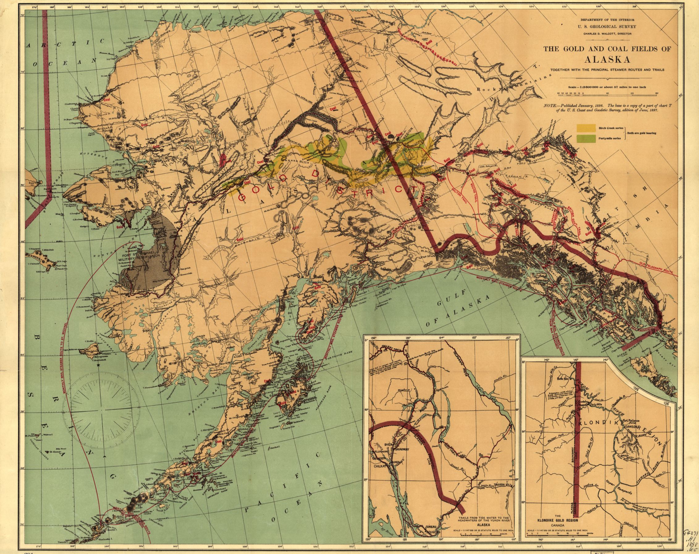
1898 Gold and Coal Fields
with principal steamer routes
Anvil City - Renamed Nome
Ayak (historical) - Former Eskimo village reported as "Ahyak" in the 1890 Census. (See Aziak and Sledge Island.) Located on Sledge Island in Bering Sea, 5 mi. off South coast of Seward Peninsula.
Aziak (historical) - Former Eskimo village reported with a population of 50 by Ivan Petroff in the 1880 census. See Ayak and Sledge Island. Located on Sledge I. in Bering Sea, 5 mi. off S coast of Seward Peninsula, 25 mi. W of Nome
Barrabora (historical) - Eskimo village, now abandoned, mentioned in 1902 by U.S. Geological Survey (USGS). It may be an altered form of "barrabara," meaning "house." A 1950 U.S. Coast and Geodetic Survey (USC&GS) field report stated that the place is a landmark in the flat country and consists of several hulks of abandoned riverboat ruins." Located on left bank of Nonvalnuk River, 11 mi. SW of St. Michael, Yukon-Kuskokwim Delta. Abandoned
Bering (historical) - Harbor town established about 1899 or 1900 to serve the placer mines along the Bluestone River. Brooks (1901, p. 68), U.S. Geological Survey (USGS), noted that by fall of 1900 it had a population of 200 and as a harbor, "has some advantage over Teller, inasmuch as vessels can easily approach much nearer the shore and have more protections from easterly and northeasterly winds." Teller, however, dominated and drew most of the people from Bering (Collier and others, 1908, p. 2770). See Teller. Located at mouth of Bering Creek, on Port Clarence, 5 mi. SW of Teller
Bessie No. 5 Dredge Camp - Site of a mining camp; name published in 1956 by U.S. Geological Survey (USGS). Description: population 54 (1950), at junction of Osborn Creek and St. Michaels Creek, 8 mi. NE of Nome.
Bluff - Site of a mining camp established in the summer of 1900 at the height of the Nome gold rush. "Bluff owes its existence to the rich beach placers which have been developed at the mouth of Daniels Creek" (Brooks, 1901, p. 67). Bluff Post Office was established in 1901 and was discontinued in 1919 (Ricks, 1965, p. 8). Balcom (1965, p. 7) noted "The Eskimos called the place by the native name for bluff, 'Agookauchuk'." Located at the mouth of Daniels Creek, on north shore of Norton Sound, 21 miles east of Solomon.
Brevig Mission - Established 1892 as Teller Reindeer Station by Sheldon Jackson, who named it for the Hon. Henry Moore Teller (1830-1914), U.S. senator 1876-82 and 1885-1909, and Secretary of the Interior (1882-85). The station was operated by the U.S. Government from 1892 to 1900. On September 1, 1900, a Norwegian Evangelical Lutheran mission was established and received 100 deer on a five-year loan from the Government (Jackson, 1906, p. 15). About 1906, the U.S. Government role diminished and the mission became dominant. The population in 1950 was 109. No population available prior to that year. In 1963 when the post office was established, the village council chose Brevig Mission to honor Reverend T. L. Brevig, the first missionary to the area. This may have been the site of an old Eskimo village. See Siniogamute. Located at mouth of Shelman Creek, on N shore of Port Clarence, 6 mi NW of Teller
Cape Nome - Site of a mining camp; reported in 1951 by U.S. Geological Survey (USGS). Located 2 mi. NE of Cape Nome and 17 mi. SW of Solomon. "Big Strike Reported to Have Been Made at Cape Nome. A letter was received in Portland May 8 from St. Michael dated January 9, from a daughter of Manager Shepard, of the North American Transportation & Trading Company at that place, giving particulars of the gold discovery at Cape Nome. She says: December 1 the Lapps and reindeer came in; also a party of men interested in the different missions, stations and camps along the coast for 125 miles. Three men brought the news of the biggest discover in Alaska at Cape Nome. The gold is found in small creeks flowing into Snake river, which empties into the sea at Cape Nome. About 200 claims have been staked already. Dozens of people immediately started for the new fields, some pulling their sleds, as dogs could not be procured. Dogs are very high this winter and there is a scarcity of them. Dr. Kittelson, who located up there, has remained the month, leaving to return tomorrow. He brought several hundred dollars in dust with him. One day he took out $600." --The Daily Alaskan, Tuesday, May 16, 1899.
Choonowuck (historical) - Site of an Eskimo village reported in 1827 by Captain Beechey (1831, p. 542), U.S. Geological Survey (USGS). Located on N shore of Grantley Harbor about 5 mi. NE of Teller
Council - (Located on Solomon D-4 USGS map.)
Cripple Creek - Site of a mining camp reported about 1940 by U.S. Coast and Geodetic Survey (USC&GS) and published on Chart 9302. Description: on left bank of Cripple River, near Arctic Creek, 15 mi. NW of Nome, Seward Peninsula High
Dahl - Former mining camp named for an early prospector. I is shown as Quartz Creek by T. G. Gerdine (in Collier, 1902, pl. 12), U.S. Geological Survey (USGS). The camp was established about 1900 at the beginning of mining in this region. The Dahl Post Office was established here in 1905 and was discontinued in 1913, although the community was active through 1914 (Balcom, 1965, p. 10). Located on left bank of Quartz Creek which flows to Kougarok River, 47 mi. SE of Imuruk Lake
Davidsons Landing - A. H. Brooks (in Collier and others, 1908, p. 308), U.S. Geological Survey (USGS), noted that up to 1906 the Kougarok gold mining district could only be reached by two long or circuitous routes. Brooks added: J. M. Davidson and Andrew J. Stone, who are among the largest operators in the district, have established a transshipping point on Kaviruk (Marys) River called Davidson Landing and have built a road from that point to the upper Kougarok region, a distance of 40 miles. Small lighters can be towed directly from the ships side at Port Clarence to Davidson Landing, so that at least one handling of freight is avoided. A post office of Davidson was established in 1906 and was discontinued the following year (Ricks, 1965, p. 16); probably at this site. Located on left bank of Kaviruk River, 1.5 mi. N of Marys Lake and 32 mi. E of Teller
Dime Landing - River supply landing for Haycock and the mining on Dime Creek, established about 1916. Located on left bank of the Koyuk River, 6 mi. S of Haycock.
Diomede - (native name Inalik, meaning "the other one" or "the one over there") is a city in the Nome Census Area, located on the island of Little Diomede (native name Ignaluk; formerly known as Krusenstern Island which can also refer to other places however).Little Diomede is the smaller of the two Diomede Islands located in the middle of the Bering Strait between the Alaska mainland and Siberia. Its neighboring island Big Diomede, Russia behind the International Date Line is less than 2.4 miles away. Diomede lies on the west side of Little Diomede and is the only settlement on the island.
East Fork - Site of a mining camp and railroad station along the Council City and Solomon River Railroad. Reported in 1904 by T. G. Gerdine, U.S. Geological Survey (USGS). Located at junction of East Fork Solomon River and Solomon River, 10 mi. NE of Solomon.
Egavik - Located on Norton Sound, 0.2 mi. S of mouth of Egavik Creek and 39 mi. SW of Christmas Mtn., Nulato Hills.
Ekathlimute - See White Mountain
Elim - Eskimo village established about 1915. A post office was established in 1943 and is continuous today. The population was 162 in 1920; 97 in 1930; and 154 in 1950. Located on NW shore of Norton Bay, 65 mi. E of Solomon
Gambell - Named in honor of Mr. and Mrs. W. C. Gambell, Presbyterian missionaries and teachers on the island from 1894 to 1898, who were drowned in 1898, while returning to Saint Lawrence after a year's leave of absence, from the sinking of the schooner Jane Grey. Named by William F. Doty, the new teacher. The name "Gambell" was painted on the front face of the station building as a memorial. (Jackson, 1900, p. 224), Located on Saint Lawrence Island, near the NW Cape of Cape Chibukak.
Golovin - Eskimo village reported in 1842-44 as "Ikalikhvig-myut" by Lieutenant L. A. Zagoskin, Imperial Russian Navy (IRN). About 1890, one of the employees of the nearby Omalik mines married an Eskimo woman and established a trading post here. This man, John Dexter, became the center for prospecting information on the Seward Peninsula With the discovery of gold in 1898, Golovin became a supply-relay point of the Council goldfields north of here. In 1899 the Chennik Post Office was established here; it was discontinued in 1903. In 1899 the Golovin Post Office was established south of here, probably at Golovin Mission; it was discontinued in 1904. John Dexter was listed as postmaster of both of these offices. A new Golovin Post Office was established at this site in 1906 and was discontinued in 1958 (Ricks, 1965, p. 10, 23, 24). The name "Golovin," derived from Golovnin Bay and Lagoon, has become well established with only one "n." The population of this village was 38 in 1890; 140 in 1900; and 135 in 1930. Located on point between Golovnin Bay and Golovnin Lagoon, 42 mi. E of Solomon
Haycock - Mining camp established about 1914. Its population was 162 in 1920; 74 in 1930; 81 in 1939; and 21 in 1950. The Haycock post office was established in 1916 and operated until 1957 Located on Eldorado Creek, 16 mi. S of Granite Mtn.
Igloo - Located on USGS Teller A-1 map.
Ikaligwigmiut - Eskimo village reported in 1842-44 as "Ikalikhvig-myut" by Lieutenant L. A. Zagoskin, Imperial Russian Navy (IRN). About 1890, one of the employees of the nearby Omalik mines married an Eskimo woman and established a trading post here. This man, John Dexter, became the center for prospecting information on the Seward Peninsula With the discovery of gold in 1898, Golovin became a supply-relay point of the Council goldfields north of here. In 1899 the Chennik Post Office was established here; it was discontinued in 1903. In 1899 the Golovin Post Office was established south of here, probably at Golovin Mission; it was discontinued in 1904. John Dexter was listed as postmaster of both of these offices. A new Golovin Post Office was established at this site in 1906 and was discontinued in 1958 (Ricks, 1965, p. 10, 23, 24). The name "Golovin," derived from Golovnin Bay and Lagoon, has become well established with only one "n." The population of this village was 38 in 1890; 140 in 1900; and 135 in 1930. Located on point between Golovnin Bay and Golovnin Lagoon, 42 mi. E of Solomon. See also Golovin.
Iron Creek - A road house was shown here on the 1908 "Map of Seward Peninsula" by Arthur Gibson. Name derived from Iron Creek, which was the center of a major gold mining region in the early 1900's. Located on left bank of Iron Creek 0.6 mi. S of its junction with Pilgrim River, 25 mi. NW of Solomon.
Klikitarik - Reindeer camp and corral reported in 1905 by U.S. Coast and Geodetic Survey (USC&GS) as "Kiktaguk." The Eskimo name "Kegiktowruk" was reported by W. H. Dall, U.S. Coast and Geodetic Survey (USC&GS), who visited it October 8, 1866. Located on S shore of Norton Sound, 18 mi E of St. Michael and 36 mi SW of Unalakleet, Yukon-Kuskokwim Delta.
Kookoolik (historical) - This is an old Eskimo village site. Archaeological site in the central part of the N coast of Saint Lawrence Island, on Kookoolik Cape E of Savoonga.
Koyuk - Eskimo village reported in 1942-44 by Lieutenant L. A. Zagoskin, Imperial Russian Navy (IRN), who recorded its name as "Kvynkhak-,iut," meaning "Kvynkhak people." Baron Otto von Bendeleben, Western Union Telegraph Expedition, wrote the name "Konyukmute" in 1865. The village became a supply center for local mining, and a trading station, called "Norton Bay Station," was established about 1900. A post office was established in 1930. Located on left bank at mouth of Koyuk River, 31 mi. NW of Christmas Mtn.
Lees Camp - Site of a mining camp; published in 1956 by U.S. Geological Survey (USGS). Located on left bank of Solomon River, 4 mi. NE of Solomon
Marys Igloo - Miners' name popularly applied to the Eskimo settlement at the head of steamboat navigation on the Kuzitrin River; reported as "Marys Igloo" by Brooks (1901, p. 11), U.S. Geological Survey (USGS), in 1900, the first year of gold prospecting in this area. transferred to flat-bottomed river boats that were towed upstream to the gold fields along the Kougarok and Kuzitrin Rivers or to the railway at Lanes Landing (Collier and others, 1908, p. 59). Balcom (1965, p. 16) attributes the name to an "Eskimo woman named Mary who held open house there for visiting miners, trappers and other travelers, who never arrived too late or too early for snacks and coffee at Mary's house, or 'igloo,' the Eskimo word for 'shelter.'" Alaska Native School was closed for lack of students by the teacher, the only white man left in the place." Igloo, which had been in continuous operation since 1901, was discontinued. in 1950. Located in Kuzitrin River basin, 2 mi. NW of Marys Mtn. and 40 Mi. SE of Teller.
Michaelovski - See Saint Michael
Moses Point - Shown as "Moses" on the 1900 "Map of Nome Peninsula" by J. M. Davidson and B. D. Blakeslee. Population 15 (1958), Located at mouth of Kwiniuk River on N shore of Norton Bay, 8 mi. NE of Elim
Moses Point Fishing Village - Located on USGS Solomon C-1 map.
New Igloo - Local name published in 1956 by U.S. Geological Survey (USGS); named relative to Igloo to the north and Marys Igloo to the east. Located on left bank of Pilgrim River 2.5 mi. SE of its junction with Kuzitrin River and 36 mi. SE of Teller.
Nome - Schrader and Brooks (1900, p11), U.S. Geological Survey (USGS), who visited the town in October 1899, spoke of the "thriving young city of Nome, first called Anvil City, now officially Nome." Gold was found in the area in the summer of 1898 and the town got its start in October 1898 when six men met at the mouth of the Snake River and formed the Cape Nome mining district. The short-lived name "Anvil City" was derived from Anvil Creek, where the first major gold was found. In June 1899, gold was found on the beaches of Nome and by August a number of men were prospecting the beaches. The news of the gold strike was carried to the States that winter and in early summer 1900 the rush was on. At the peak that summer there were 30,000 people at Nome, but 16,000 left in 13 weeks (Rickard, 1909, p308-337). Nome incorporated on April 9, 1901. The population was 12,488 in 1900; 2,600 in 1910; 852 in 1920; 1,213 in 1930; 1,559 in 1939; and 1,876 in 1950. A post office was established here in 1899. Located on S coast of Seward Peninsula on Norton Sound
Pelazuk (historical) - Site of an Eskimo village reported in 1907 as "the old native village Palazruk" (Collier and others, 1908, p. 59). no population can be associated with the village, the 1954 U.S. Coast and Geodetic Survey (USC&GS) Coast Pilot still refers to "The native village of Pelazuk" (p. 551). Located on coast of Bering Sea, 8 mi. SW of Cape Prince of Wales and 48 mi. NW of Teller.
Perkinsville - Site of mining camp and RR station reported in 1904 by T. G. Gerdine, U.S. Geological Survey (USGS). The exact date of the camp is unkown; however, gold was discovered on Anvil Creek in 1898 and the RR was built in 1900. Located on left bank of Anvil Creek, 3.8 mi. N of Nome
Pilgrim Springs - Mineral Springs and site of a resort. gold mining on Seward Peninsula, about 1900, the property was known as "Kruzgamepa Hot Springs" and "was kept up as a resort, and was often visited by parties from Nome and other mining centers of the region; but the roadhouse and saloon building was burned in 1908 * * *" (Waring, 1917, p. 72). town called "Pilgrim Springs" grew up here and "was active from 1923 to 1941. Since moved to the Nome vicinity to work on defense projects and mining operations" (Balcom, 1965, p. 27). Springs Post Office was established in 1924 and discontinued in 1941. Located on Left bank of Pilgrim River, 13 mi. NE of Salmon Lake and 25 mi. SW of Mount Bendeleben
Port Clarence - Located on USGS Teller B-4 map.
Port Safety - Site of a mining camp established in the summer of 1900 at the height of the Nome gold rush (brooks, 1901, p. 66). Safety Post Office established here in 1900 and discontinued in 1902 (Ricks, 1965, p. 55). Name was taken from the lagoon. Located on spit between Safety and Norton Sounds 6 mi. E of Cape Nome and 14 mi. SW of Solomon
Redoubt Saint Michael - See Saint Michael
Saint Michael - About 1833 the Russians established a stockaded post, which, "according to (Lt. L. A.) Zagoskin, Imperial Russian Navy (IRN), was named after Captain Michael Dmitrievich Tebenkov, afterwards governor of the Russian-American colony." Later the name was changed to "Michaelovski." or "Redoubt Saint Michael." and included the village of Techek. An American military post, called "Fort Saint Michael," were established in 1897, following the Klondike gold strike and the subsequent increased Yukon River traffic, most of which originated at Saint Michael. Located on E coast of St. Michael I. in Norton Sound, 43 mi. SW of Unalakleet.
Savoonga - This is a relatively new Eskimo village with a population of 139 in 1930; 209 in 1939; and 249 in 1950. A 1965 census shows a population of 397. The Savoonga post office was established in 1934. Located on Savoonga Point in the central part of the N coast of Saint Lawrence Island, 39 mi. SE of Gambell.
Serpentine Hot Springs - Mineral springs and site of a settlement. Collier (1902, p. 55), U.S. Geological Survey (USGS), notes "Charles McLennan, who with a dog team and Eskimo assistants * * * in May 1900 * * * was the first white man to reach the hot springs." Collier further noted that in September 1901 he found a small settlement at the hot springs. Waring (1917, p. 76), U.S. Geological Survey (USGS), referred to this as "Arctic Hot Springs" and noted "A few years ago prospectors built a cabin near the upper spring and a bathhouse over a bathing pool * * *." The name "Serpentine Hot Springs" came into local use and was published in 1951 by U.S. Geological Survey (USGS). Located on Seward Peninsula, left bank of Hot Springs Creek near the headwaters of the Serpentine River, 7 mi NNW of Midnight Mountain and 12 mi N of Taylor
Shaktoolik - Eskimo village reported in 1842-44 by Lieutenant L. A. Zagoskin, Imperial Russian Navy (IRN), who recorded it as "Tshakhtog-myut." The population was 60 in 1880; 38 in 1890; 73 office was located here from 1930 to 1933 and from 1944 to 1949 (Ricks, 1965, p. 58). Located on the E shore of Norton Sound, 12 mi SE of the entrance to Norton Bay, Cape Denbigh, Nulato Hills.
Shishmaref - Eskimo village named for the inlet. Shishmaref post office was established here in 1901. The village was probably founded about 1900 because of a fairly good harbor that served as a supply center for mining activity to the south. Located on Sarichef I., between Chukchi Sea and Shishmaref Inlet.
Sinuk - Site of an Eskimo village reported in 1900 by E. C. Barnard (in Brooks, 1901, pl. 17), U.S. Geological Survey (USGS). See Siniogamute. Located at mouth of Sinuk River, on Bering Sea coast, 26 mi. NW of Nome.
Solomon - Established as a mining camp in the summer of 1900 at the height of the Nome gold rush (Brooks, 1901, p. 66). The name "Erok" was shown here on the 1900 "Map of Nome Peninsula" by J. M. Davidson and B. D. Blakeslee. A post office was established here in 1900, discontinued in 1925, reestablished in 1928, and finally discontinued in 1956 (Ricks, 1965, p. 60). In 1965 Balcom (p. 30) noted: "there was one Alaska Native Service school here. There are still a few white families mining in the area but most of the Eskimos have moved to more prosperous towns to find employment." Description: Population 12 in 1958. Located on the west bank of the Solomon River, 1 mile north of Norton Sound and 30 miles east of Nome.
Stebbins - Village which a 1950 U.S. Coast and Geodetic Survey (USC&GS) field report gave as primarily Eskimo with about "80 people whose main livelihood is hunting, fishing, and herding reindeer." The village was first mentioned in 1898 by U.S. Coast and Geodetic Survey (USC&GS); the name was published in 1900 on Chart 9370. Its Eskimo name is reported to be "Atroik." Located on NW coast of St. Michael I., 8 mi. NW of St. Michael.
Sullivan Camp - Located in USGS Teller A-3 map.
Taylor - Mining camp founded about 1906. A post office of this name was established in 1906 and discontinued in 1934 (Ricks, 1965, p. 64). Taylor served as a center for the upper Kougarok gold mining region. Population 29 (1940), Located on left bank of Kougarok River, 8 mi. SW of Midnight Mtn. and 48 mi. W of Imuruk Lake.
Techek - See Saint Michael
Teller - In 1827 Captain Beechey (1831, p. 543), Royal Navy (RN), reported that at this place "called Nooke by the natives, there were some Esquimaux fishermen * * *. They appeared to have established themselves upon this point for the purpose of catching and drying fish." This location was used in the winter of 1866-67 as quarters by Captain Daniel B. Libby's section of the Western Union Telegraph Expedition, and was known as "Libbysville" or "Libby Station." In 1867 "The Esquimaux," a monthly newspaper, which was published there, noted (July 2, p. 38), "Nook, the spot which divided Grantley Harbor from Port Clarence." In the 1880 Census, Petroff (1884, p. 11) listed a "Nook" at Cape Douglas with a population of 36 Eskimo. It is doubtful that any permanent settlement was established here before 1900, when the village of Teller "was founded * * * after the Bluestone placers, 15 miles to the south, were discovered. Located on a spit between Port Clarence and Grantley Harbor, 55 mi. SE of Cape Prince of Wales.
Tin City - Former mining camp established at the base of Cape Mountain in 1903 (Collier, 1904, p. 59). Tin ore was discovered on Cape Mountain in July 1902, by Mr. W. C. J. Bartels. * * *Extensive developments were planned for the season of 1903, and a well-equipped prospecting plant was sent to Cape Mountain" (Collier, 1904, p. 25). By 1907 "a few widely scattered houses" formed Tin City (Knopf, 1908, p. 35), and two companies operated out of the village and a 10-stamp mill was located here (p. 40). Tin City post office was established in 1904 and was discontinued in 1909 (Ricks, 1965, p. 65). Located at mouth of Cape Creek, on Bering Sea Coast, 5 mi. SE of Cape Prince of Wales.
Unalakleet - Eskimo name spelled "Ounalaklik" by Lieutenant L. A. Zagoskin, Imperial Russian Navy (IRN), on an 1850 map. Ivan Petroff lists "Oonalakleet," population 100, in the 1880 Census, population 175 in 1890; 247 in 1910; 285 in 1920; 261 in 1930; 329 in 1939; and 469 in 1950. Because it is the terminus of a long used winter route from Anvik on the Yukon, the inhabitants are a mixed race of Eskimo and Indian. The Unalakleet post office was established in 1901. Located on Norton Sound, N of mouth of Unalakleet River, Nulato Hills. "Nome and Seward Peninsula" says Unalakleet was founded in 1840.
Ungalik - an abandoned town near Shaktoolik
Wales - In August 1826 Captain Beechey (1831, p. 291), NR, wrote "At this last metioned cape (Cape Prince of Wales), they (Eskimo) placed a village, called Iden-noo; and a little way inland another, named King-a-ghee, which was their own winter residence." In 1827 (ibid p. 540) he recorded the spellings "Ei-dan-noo" and "King-a-ghe", and noted (ibid p. 543), "These were some of the most cleanly and well-dressed people we had seen anywhere on the coast. Their residence was at King-a-ghe---a place which, must be important among the Esquimaux (sic) villages upon the coast." Captain E.E. Smith, U.S. Revenue-Cutter Service (USRCS), reported "Kingigamute,: population 400, in the 1880 Census. The 1890 Census listed a population of 488. In 1890 the American Missionary Association of the Congregational Church established a mission (Brooks, 1901, p. 23), and in 1894 a U.S. Government reindeer station was organized. Wales post office was established in 1902 Located at mouth of Village Creek on coast of Cape Prince of Wales at W end of Seward Peninsula.
White Mountain - Established in 1899 when C. D. Lane put up a large warehouse as headquarters for the supplies he intended to use on his numerous gold claims i n the Council district (North American Transportation and Trading Company, 1900, p 25). The name was derived from the mountain on its north side. Colby (1939, p. 363) referred to this as a fishing villaage with a population of 205. A post office was established in 1932 and continues today (Ricks, 1965, p.70-71). The population was 198 in 1920; 205 in 1930; 199 in 1939; 129 in 1950; and 151 in 1960, of whom 119 were Eskimo. See Ekathlimute. Located on left bank of Fish River, 15 mi. NW of Golovin and 33 mi. NE of Solomon.
York - Site of a mining camp established in 1899. U.S. Geological Survey (USGS), noted; "In the spring of 1900 York promised to be a place of importance, but in the early fall its population had been reduced to about twenty or thirty." he widely disseminated the announcement that stream tin had been found in the vicinity of York (Steidtmann and Cathcart, 1922, p. 13-14). The latter part of the season (1901), a great many prospectors searched the York region for tin" (Collier, 1904, p. 11). Office was established here in 1900 and was discontinued in 1902. Located on Bering Sea coast, at mouth of Anikovik River, 14 mi. SW of Cape Prince of Wales and 41 mi. NW of Teller.
Copyright © 1996 - The USGenWeb® Project, AKGenWeb, Nome Census Area

This page was last updated
06/19/2025